The new Bougie road reaches, on the S. slope of Jebel ou Chiouen (3289 ft.), the upper valley of the Oued el-Kseur, a dull, uninhabited forest region, and then nears the S. base of the bare Jebel Arbalou.
Farther on, in the vale of the Oued Rhir, we cross the La Réunion and Toudja road (p. 252).
Toudja (650–1000 ft.) is a group of Kabylian villages in the abundantly watered upper valley of the Oued Rhir and on the S.E. slope of Jebel Toudja (1998 ft.), the E. spur of Jebel Arbalou (4291 ft.), the latter of which may be scaled in 3–3½ hrs. Toudja is famed for its oranges. The modern Bougie, like the ancient Saldæ (p. 263), is supplied with water from the springs of Toudja. The Roman Aqueduct was 13 M. long; remains of its pillars are still to be seen on the Col d’El-Hanaïat (about 1475 ft.), ½ hr. to the N.E. of Toudja.
Lastly we descend into the vale of the Oued Srir (p. 252) and reach (77½ M.) Bougie (see below).
41. Bougie.
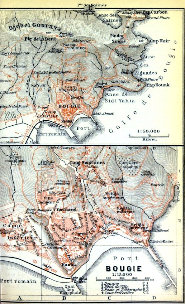
Railway Station (Pl. B, 3), in the plain, to the W. of the old town, not far from the Kasba hill.
Arrival by Sea. The steamers of the Comp. Générale Transatlantique (RR. 20, 22; office on the quay) anchor close to the Jetée Abd el-Kader (Pl. D, 3). Landing or embarkation 30, trunk 30–60 c.; small articles free.
Hotels (comp. p. 174). Hôt. de France & Royal (Pl. a; C, 2), Chemin de l’Hôpital, quiet, R. 4–6, B. 1½, déj. 3½, D. 4, pens. 12–14, omn. 1 fr.—Hôt. d’Orient (Pl. b; C, 2), R. 3–6, B. 1, déj. 3, D. 3½, pens. 10½–13½, omn. ½ fr.; Hôt. des Voyageurs (Pl. c; C, 2), poor; these two in Rue Trézel, with splendid view.
Café. Richelieu, with terrace, Rue Trézel.
Post & Telegraph Office (Pl. 3; B, 3), Place Gueydon, corner of Rue Trézel.—Banks. Banque de l’Algérie, next to the post-office; Comp. Algérienne, etc.
Carriages let out by Spiteri, Pacce, and Ali ben Abdelkrim Frères. Arrangements should be made personally with these or the drivers.—Motor Cars let out by Vogelweith, Rue Jeanne d’Arc.—Motor Omnibus, Messageries Automobiles Djidjelliennes.—Diligence Offices, Place Gueydon and Rue Trézel.
Sea Baths in the bay of Sidi Yahia (p. 264).
One Day (when time is limited). In the morning, visit to Cape Carbon (p. 264); in the afternoon, walk round the town and the bay of Sidi Yahia. Photographing and sketching in or around Bougie are prohibited.
The quiet seaport-town of Bougie (pop. 11,000, of whom 6000 are Mohammedans and 600 Jews), defended by several forts, rises in terraces on the W. shore of the bay of that name, at the S. base of the steep Jebel Gouraya (p. 265). The Anse de Bougie or d’Abd el-Kader, a small bay between two headlands, the Kasba Hill to the W. and the Bridja Hill to the E., forms the harbour. The so-called Darsenâa (see p. 90), the ancient Roman and Moorish harbour adjoining the plain to the W. of the Kasba Hill, and near the industrial suburb close to the station, is now choked with the deposits of the Oued Sahel (p. 251). The upper part of the Kasba Hill to the N., above the new French quarters, is the Ville Indigène or Kabylian quarter (Pl. A, B, 1, 2), whose red-tiled stone huts resemble those of the villages of Great Kabylia (p. 252). A second native quarter, the Faubourg des Cinq-Fontaines (Pl. B, C, 1), lies in the upper part of the valley, between the two hills.
The environs of Bougie, owing to the copious winter rainfall (p. 170), are remarkable for their luxuriant vegetation and their splendid timber. The town is most beautiful in spring, when the gardens don their freshest verdure and the terraces and slopes are gorgeously carpeted with bougainvilleas. In winter the blue bay contrasts most picturesquely with the snow-clad mountains of Little Kabylia (p. 266).
Under the Carthaginians Bougie, like Igilgili (Djidjelli), was probably one of the chief seaports on this part of the coast, but its Punic name is unknown. In the Roman period, under the name of Saldae, it was the principal town on the bay. Its present name (Ital. and Span. Bugia) is derived from the Berber tribe of the Bejaïa or Bujaïa, who settled in the vicinity in the 10th century. The town attained its brief prime in the middle ages, and was one of the most flourishing of the minor Moorish principalities when under the sway of the Hammadites (1090–1152), fugitives from Kalàa des Beni-Hammad (p. 270). The Pisans, the Genoese, and the Venetians had their factories here. Wax being the chief export, the French still call their wax-candles bougies (originally, in Ital., candele di Bugia). From the 15th cent. down to the French occupation, save during the Spanish period (1510–55), when it afforded an asylum to Emp. Charles V. on his retreat from Algeria (1541; comp. p. 221), it was a notorious haunt of the barbaresque pirates. The recent improvement of the harbour is expected to revive the ancient prosperity of the place.
The finest mediæval building in the town is the dilapidated Porte Sarrasine (Pl. C, 2; Arabic Bâb el-Bahar, sea-gate), probably a relic of the town-walls erected by the governor En-Nasr, in 1067, extending along the top of the two headlands, up to the Plateau des Ruines (p. 265).
Since the 16th cent. the bay has been commanded by the Kasba (Pl. B, 3), a fortification of the Spanish period, and the ruinous (originally Turkish?) Fort Abd el-Kader (Pl. D, 2, 3) on the rocky summit of the Bridja Hill. Both are now barracks (no adm.).
The Harbour, exposed to the infrequent N. and N.E. winds only, one of the ‘least bad’ in Algeria, and now 65 acres in area, was improved in 1905–9 by the extension of the Jetée Abd el-Kader (Pl. D, 3; a fine point of view), by the formation of a quay at the Pointe de la Kasba, and by the construction of the Jetée du Large, an outer breakwater, 525 yds. long.
The town is entered from the harbour either by the Boul. des Cinq-Fontaines (Pl. C, 2, 1) or by the Rue de la Marine (Pl. C, 2) and Rue Duvivier, all ascending to the Rue Trézel. From the railway-station we ascend to the Place de l’Arsenal by the Rampe of that name (Pl. A, B, 2).
The Rue Trézel (Pl. B, C, 2), which ascends to the S.W. from the lower ground to the Kasba Hill, is the only fairly animated street in the town. On the left is the Hôtel de Ville (Pl. 2; C, 2), which contains a few antiquities, including a Roman mosaic (Oceanus and the Nereids) found near the hospital. The Fountain in front of the Hôtel de Ville has a hexagonal column with a Roman inscription in three parts recording the building of the aqueduct (p. 262).
The Place Gueydon (Pl. B, 2, 3), the focus of traffic, named after Admiral Gueydon (governor of Algeria, 1870–3), and adorned with a Monument (a genius in bronze), affords a splendid *View of the bay from the parapet.
From the Rue Trézel we cross the Place de l’Arsenal (Pl. B, 2) and ascend the Rue Fatima to the booths of the Kabylian Market and to the Kabylian quarter, the chief boast of which is the pretty Mosque (Pl. A, B, 2), completed in 1902. Close by is the Porte Fouka (Pl. A, 2), the substructions of which are ancient.
Fort Barral (Pl. B, 2; formerly Fort Moussa), to the E. of the Rue du Gouraya (p. 265), dates from the Spanish period. Behind the Hôpital Civil are the Citernes Romaines (Pl. B, 1; 509 ft.), which have been frequently altered. These and a few fragments of the Roman Town Walls are the sole memorials of antiquity.
The Rampe des Spahis (Pl. B, 2, 1) descends to the Cinq-Fontaines (Pl. C, 1), a Mauro-Turkish fountain in the valley, whence the Chemin de Bridja leads to the Porte du Cimetière (Pl. C, 1), the town-gate on the Bridja Hill.
A charming walk is afforded by the road from the gate just named, passing the Jewish Burial Ground (Pl. D, 1), and descending in windings through olive and carob groves and ruins of old fortifications, to the beautiful Anse de Sidi-Yahia. Thence, at the lime-kiln and cement-works, we may either turn to the right and go through the tunnel under Fort Abd el-Kader (p. 263) back to the harbour, or we may follow the coast-road (p. 265) leading to the E. to the bay of Les Aiguades.
The *Excursion to Cape Carbon (there and back 3½–4 hrs.) is best made on foot or by mule (3 fr., attendant 1 fr.). We leave the town by the Porte du Cimetière and follow the rough road to the N.E., passing (on the left) the Catholic Cemetery (Pl. C, D, 1), and ascending amidst rich vegetation on the E. slope of Jebel Gouraya (p. 265).
Passing the pleasant path which diverges to the Petit Phare (482 ft.) on Cape Bouak, we soon reach the Vallée des Singes, whence we look down on the peaceful Anse des Aiguades (p. 265), and the (1 hr.) Pic des Singes, on whose steep rocky slopes we may often see monkeys disporting themselves (comp. p. 171). Just beyond the short rock-tunnel, where the road ends, we obtain a superb **View of Cape Carbon (722 ft.), whose limestone precipices, descending sheer on every side, are crowned with a semaphore and the old lighthouse. We cross the low saddle between the Anse des Salines (see below) on the left and the bay bounded by Cape Carbon and the Cape Noir (p. 130) on the right, and ascend past the Old Lighthouse to the (20 min.) *Semaphore, from whose flat roof we have a splendid survey of the bay and of the bold coast of Great Kabylia as far as the Ile Pisan (p. 130).
From the saddle just mentioned a path descends to the New Lighthouse at the foot of Cape Carbon.
The beautiful new *Coast Road leads round the Anse de Sidi-Yahia (p. 264), passing the marabout of that name and the large quarries and skirting the abrupt slopes of Cape Bouak (p. 264). It pierces the point of the cape by means of a short tunnel, and ends, beyond the old pumping-works, at the *Anse des Aiguades. Its extension to the new lighthouse at Cape Carbon is projected.—When the sea is calm we may row from the harbour of Bougie (4–5 fr.; bargain necessary), past Cape Bouak and through the Roche Percée at Cape Carbon, to the Anse and the Pointe des Salines, with the Grotte Ste. Anne. On the return we may for variety land in the Anse des Aiguades and walk back to Bougie by the coast-road.
The ascent of Jebel Gouraya (2166 ft.) takes 2–2½ hrs. on foot or 1¾ hr. by mule (3 fr., and fee of 1 fr.). We first follow the Rue du Gouraya and Chemin du Gouraya, or else a road on the Bridja Hill above the Faubourg des Cinq-Fontaines, to the Porte du Grand Ravin (Pl. B, 1). A steep road ascends thence in windings, through underwood, to the Plateau des Ruines, where there is a Pénitencier for military convicts. Hence a path leads in ½ hr. to the small Fort du Gouraya, within which is the shrine of Lalla Gouraya. We then ascend to the right, round the fort, to the cairn on the W. peak, where we are rewarded with a charming view of the bay, the lower Sahel valley, the coast of Great Kabylia as far as Cape Sigli (p. 130), and Jebel Arbalou (p. 262).
Excursion to Toudja (carr. 20–30 fr.), and drive viâ Taourirt-Ighil to Azazga (and Fort-National), see pp. 262, 261.
42. From Bougie through the Chabet el-Akra to Sétif.
72 M. Road. Motor-omnibus (p. 262) from Bougie at 6 a.m., in 7½ hrs. (to Kerrata, déjeuner station, in 4¾ hrs.); from Sétif at 7 a.m., in 6½ hrs.; fare 25 fr. 20 or 12 fr. 20 c. (to Kerrata 11 or 4 fr.); luggage at the rate of 10 fr. per 100 kilos (220 lbs.) for every 100 kilomètres (62 M.). Also a diligence to Kerrata, both from Bougie and from Sétif: from Bougie at 3.30 a.m., in 7½ hrs., from Sétif, at 5 a.m., in 6 hrs. (allowing an hour for lunch at Kerrata, 11–12); fare for the whole journey 15 fr. (intérieur 8 fr.). Those who do not care for the unattractive drive from Kerrata to Sétif, where there is direct correspondence in the direction of Constantine and Biskra only, or who are bound for Djidjelli, will return at once from Kerrata to Bougie.—Private carr. from one of the hirers at Bougie (p. 262) to Sétif about 100–140 fr. (or to Kerrata and back 50–60 fr.). Motor-car at Vogelweith’s (p. 262) ½ fr. per kilomètre Carr. from Sétif to Bougie 120, half-open (calaffe) 100 fr.; it is possible to drive all the way in one day, but in the reverse direction (Bougie to Sétif) it is best to spend a night at Oued-Marsa or Kerrata.
The road skirts the gulf of Bougie (p. 130) all the way to the deep depression of the Agrioun Valley. Between Bougie and Kerrata it passes through the finest scenery of Little Kabylia or Petite Kabylie, a wooded hill-region, thinly peopled by Berber tribes. The Chaîne des Babors, the higher mountains, unlike those of the Jurjura (p. 258), rise but little over the intermediate hills. The Chabet el-Akra is the grandest mountain-defile in Algeria.
Bougie, see p. 262. The Road leads through the suburb at the station and then to the S.W. across the plain of the Oued Srir (p. 252).
Passing through the featureless plain on the right bank of the Oued Sahel (p. 251), we obtain retrospects, growing finer as we advance, of Bougie and Cape Bouak and then of Cape Noir and Cape Carbon also. We soon reach the vine-clad coast-plain on the verge of the wooded hills of Little Kabylia, where the cork-oak abounds, and for a time turn away from the sea.
Halfway between Bougie and Cape Aokas the coast-plain narrows. High above the rocky shore the road mounts a spur of the Beni Mimoun Djoua Mts., and then the (10½ M.) Pointe Tichi, an offshoot of the Beni Amrous hills, beyond which it descends, in view of the picturesque Cape Aokas and the coast as far as Cape Cavallo (p. 267), into the vine-clad valley of the Oued Djemâa. At the (12½ M.) bridge over the stony bed of the stream, we observe up the valley the Beni Slimane Mts. (4160 ft.) and those of Beni Bou Aïssi, with the lofty Jebel Imoulentaour (5715 ft.).
Beyond the Djemâa valley begins one of the finest parts of the coast. The hills again come down close to the shore. The road passes the handsome Villa Poizat, with its great wine-cellars, and crosses the wild Oued Zitoun. On the slope above the torrent is a pretty farm-dwelling, nestling among eucalypti, bananas, and bamboos. We next round the Cône d’Aokas (1519 ft.), precipitous all round, and come to a bend in the road at (15 M.) Cape Aokas, where we have a beautiful *View of the whole bay.
Just before the village of Oued-Marsa, 6 min. beyond the cape, is the prettily situated little Hôt. du Cap Aokas (R. 2½–3, B. 1, déj. or D. 3½ fr., quite good). The road now enters the broad coast-plain between the Oued Marsa and the Oued Agrioun, lately brought under cultivation, overlooked by the Beni Hassain Mts. (4567 ft.), and still showing a few vestiges of the primæval Forêt d’Acherit, a swampy region notorious for malaria.
We cross the Oued Sidi Réhane and pass the village of that name, with its kubba shaded by venerable trees. A double tunnel under the bed of the torrential Oued Sidi Resgoun next brings us to the broad mouth of the Oued Agrioun.
22 M. Souk et-Tenine (Hôt. des Voyageurs, déj. 1½ fr., poor), the Monday market of the Beni Hassain, lies on a low hill at the entrance to the Agrioun valley. The road ascends on the left bank of the valley, flanked with cork-trees and beautiful underwood.
The road to Djidjelli diverges at the 36th kilomètre-stone (22½ M.) to the left from the Sétif road.
The beautiful Djidjelli Road (from Bougie 60 M.; motor-omnibus daily, fare 14 fr. 30 or 10 fr. 30 c.; diligence daily at 5 a.m., in the reverse direction at 4 a.m., in 12 hrs., fare 10 or 7 fr.; provisions should be taken for the journey) continues to skirt the bay of Bougie, passing at places through fine old forest of cork-trees, pines, etc., thickly overgrown with creepers. It crosses the Oued Agrioun beyond the 36th kilomètre-stone and the Oued Boulzazène, and then returns, to the N.E., to the coast.
Near the 42nd kilomètre-stone (26 M.) begin the *Grandes Falaises, a series of bold cliffs, extending along the coast for 1¼ M., through which the road is tunnelled at places. Fine view of the bay behind us, as far as Jebel Gouraya. We next skirt two secluded bays, separated by Jebel Afoerer (473 ft.), pass the Pointe Ziama (450 ft.), and cross the Oued Ziama.
32 M. Ziama consists of a group of settlers’ dwellings near the site of Choba, a Roman seaport, where there are still considerable remains of the Roman town-walls, of baths dating from 196 A. D., and of the Byzantine ramparts.
Beyond the cliffs of Pointe Mansouria (hotel), off which rises the rocky islet of that name, we come to (37½ M.) the mouth of the Oued Guelil or Dar el-Oued, near the stalactite Grottes de Mansouria or de Dar el-Oued, discovered in 1901. The chief grotto, 165 yds. long and 16 ft. high, is lighted with acetylene (adm. 1 fr.).
Passing several caverns on the coast, we next skirt the small Anse de Taza, at the mouth of the Oued Taza, which, farther up, has carved out a grand defile through the S. margin of Jebel Taounnart (2546 ft.). Partly through cuttings and tunnels, the road now leads to (47½ M.) the village of Cavallo, near Cape Cavallo (p. 130), the E. limit of the bay of Bougie. Near it are large granite-quarries.
Off the rocky coast lie on the left the islets of Grand and Petit Cavallo (p. 131). 50½ M. Montaigne or Agadie is the only European settlement on this part of the coast. A little beyond the Oued Kissir a road diverges to the left to the lighthouse on the Râs Afla (p. 131). Our road skirts the wooded flanks of Jebel Mes Ritan or Mezritane (1294 ft.), and at the Anse el-Kalâa sweeps round to the S., inland. Lastly, passing the small Anse des Beni-Caïd (see below), it reaches the Porte de Bougie, the W. gate of—
60 M. Djidjelli (Café de France, R. 2 fr., déj. or D. 2 fr., quite good; pop. 6400, incl. 5000 Mohammedans), a poor seaport, consisting mainly of two streets planted with fine plane-trees. This was the ancient Igilgili, once an important mart of the Carthaginians, which in the middle ages long retained its trade as the seat of a Genoese factory, but after its occupation by Horuk Barbarossa (p. 221) became a mere den of pirates. The small Harbour, open towards the E., and inadequately sheltered on the N. and N.E. sides, admits lighters and fishing-boats only. On the adjacent Crique de l’Ouest rise the Citadel and the Poudrière, an old fort. At the Vigie, the clock-tower on the neighbouring aloe-clad hill, we enjoy a charming view of the hill-region around, noted in spring for its gorgeous wealth of flowers, backed by Jebel Sedderts (3153 ft.) to the E. and by the inland hills of Little Kabylia. To the W. of the town, particularly on the headland between the Anse des Beni-Caïd and the Anse el-Kalâa (see above), are many Punic Rock Tombs, now empty.
A highroad leads from Djidjelli to (42½ M.) El-Milia, (84½ M.) Collo (p. 131), and (95½ M.) Robertville (p. 303; motor-omnibus in 10 hrs., fare 25 fr. 30 or 20 fr. 30 c.); another viâ (66 M.) Mila (Hôt. du Commerce, R. 2 fr., déj. or D. 2 fr., tolerable), the Roman Mileum (with an interesting, well-preserved Byzantine town-wall), to (102½ M.) Constantine (p. 297).—Railway viâ El-Milia and Mila to Constantine projected.
The Sétif Road ascends gradually to the S., on the left bank of the wooded Agrioun valley, at the E. base of the hills of the Beni Hassain (p. 266). On the opposite bank, on the slope of the finely shaped Jebel Beni Bou Youssef (3061 ft.), runs the new mineral railway of Tadergount (see below). 25 M. Aux Deux-Fontaines (about 410 ft.; inn).
The road ascends more steeply, high above the river-bed. At a bend just before the 43rd kilomètre-stone we have a splendid survey of the central Agrioun valley, enclosed in a semicircle by the lofty and barren crests of the Chaîne des Babors. The road then descends to the S.W. into the valley again. To the left we look into the lateral valley of the Oued Tiraz, with the iron-glance mines of Tadergount, on the slope of Jebel Beni Felkaï (4452 ft.). Wild oleanders abound in the bed of the Agrioun. On the wayside are several Kabylian huts with orange and fig-gardens.
Beyond the 49th kilomètre-stone we see, high above us, on the right, Beni-Ismaïl or Smaïl, a mission-house of the White Fathers (p. 247) called after the tribe of that name, placed near a waterfall between Jebel Imoulentaour (p. 266) and Jebel Takoucht (6221 ft.).
Beyond the 50th kilomètre-stone (31 M.) two massive pillars of rock mark the lower end (about 590 ft.) of the **Chabet el-Akra, the grand ‘ravine of death’ (4½ M. long), between the bold and partly bush-clad Jurassic rocks of Jebel Takoucht, on the W., and Jebel Adrar Amellal (5817 ft.) and Kef Randek, on the E. An inscription on the rock to the right records the construction of the extremely costly road (1863–70). Monkeys (p. 171) are sometimes seen on the hill-sides.
Near the 54th kilomètre-stone (33½ M.) the road crosses the stream, which dashes over huge rocks far below the bridge, whence we have a fine view down the valley. About ½ M. farther the valley again contracts to a narrow defile. An inscription on a slab of rock in the bed of the stream recalls the first march of French troops through the gorge (1864). In the foreground rises a great rocky cone called the *Pain de Sucre (Arabic Drâ-Kalawi), apparently closing the valley. Passing some strange rock-dislocations, with vertical strata, we reach (35½ M.) the upper end of the gorge.
37½ M. Kerrata (1575 ft.; Hôt. du Chabet, R., déj., D., each 2½–4 fr., very fair; Hôt. de Kerrata, humble; Tues. market), a village of the Beni Meraï tribe, lies in a bleak hill-plain, adjoining the stony S. slope of the Chaîne des Babors.
From Kerrata viâ Aïn-Abessa to Sétif, 34 M., pleasanter, by carr. or cycle, than the main road viâ El-Ouricia, particularly in the reverse direction. This road leaves the highroad near (3¾ M.) the mouth of the Oued Atteba, one of the sources of the Agrioun, ascends its valley, and crosses a pass to (17½ M.) Aïn-Talaouart. Here to the right diverges the so-called Route des Caravansérails to the little town of Aïn-Roua (3806 ft.), at the foot of Jebel Anini (5243 ft.), noted for its mineral wealth, and to the sulphur-baths of Hammam-Guergour or Sidi el-Djoudi, in the Massif de Guergour, which were already known to the Romans. From Aïn-Talaouart our road turns to the S.E. and ascends past the (20½ M.) village of Aïn-Abessa (3616 ft.; Hôt. Copel) to the saddle (4019 ft.) between Jebel Megriss (5700 ft.) and Jebel Matrona (4679 ft.). Descending to the Oued Bou Sellam (p. 251) the road here rejoins, a little before (30 M.) Fermatou (see below), the main road to (34 M.) Sétif.
The highroad ascends out of the Agrioun valley, soon offering a glimpse of Jebel Babor (6575 ft.) on the left, and mounts in windings, to the S.E., through a once wooded hill-region to the (48 M.) Tizi N’Béchar (2910 ft.), 1¼ M. below the large Berber village of Takitount (3448 ft.), and 2 M. to the W. of Aïn el-Hamda, a village noted for its mineral water, known as ‘eau de Takitount’. We descend from the pass to (52½ M.) Amoucha (Hôt. des Voyageurs, déj. 3½ fr.), in the upper valley of the Agrioun.
A road leads to the S.E. from Amoucha to (7½ M.) Périgotville, the chief village in the Canton de Takitount, on the Oued Aïn-Kebira. It lies on the site of the small Roman town of Satafis. The school-yard contains a few antiquities. Diligence viâ El-Ouricia (see below) to Sétif (p. 271).
As the road ascends we have another view of Jebel Babor. It winds up to the S. to the (59½ M.) Teniet et-Tine (3806 ft.), a pass on the N. margin of the plateau of Sétif (p. 271) commanding fine views, and then descends to (64½ M.) El-Ouricia (3543 ft.), a village near the head of the Oued Bou Sellam valley (p. 251), with a few vineyards. 68 M. Fermatou, at the mouth of the brook of that name.
72 M. Sétif, see p. 271.
43. From Algiers to Constantine viâ Beni-Mansour, Sétif, and El-Guerrah.
288½ M. Railway (comp. p. 173). Two express trains daily in 12¼–12¾ hrs. (fares 51 fr. 95, 37 fr. 10, 27 fr. 85 c.), one in the morning (with dining-car), the other in the evening (sleeping-berth 15 fr. extra). El-Guerrah is the junction for Biskra (R. 44); Le Khroub for Bona (R. 48) and Souk-Ahras (and Tunis; RR. 49, 51). Railway Restaurants at Bouïra, Beni-Mansour, Sétif, El-Guerrah, and Le Khroub.
From Algiers to (107 M.) Beni-Mansour, see R. 37. The train now leaves the Sahel valley (p. 251), enters, to the S., the valley of the Oued Mahrir, and passes through a series of gorges flanked with blackish limestone rocks, between the hills of the Beni Abbès on the left and the Beni Mansour on the right, here almost uninhabited. To the left we have a final glimpse of the Jurjura range (p. 258) behind us.
115 M. Les Portes-de-Fer, the first station in the province of Constantine, with a Sunday market, lies at the entrance of the two passes over the Chaîne des Biban (pl. of bâb, gate) or Chabet es-Sétif. These are the *Grande-Porte (Arabic Bâb el-Kebîr), through which flows the Oued Chebba, the main branch of the Oued Mahrir, and the Petite-Porte (Bâb es-Serîr), the ravine of its tributary the Oued Bou-Ketoun. The train runs through the former of these passes, a grand defile, where the rocks are curiously stratified.
125 M. Mzita (1811 ft.) lies in a bleak plain on the S. margin of the Chaîne des Biban. The train now ascends rapidly to the S.E., between Jebel Mzita (4813 ft.) on the left and Jebel Kteuf (6109 ft.) on the right, to (130 M.) Mansoura (2297 ft.), a village of immigrant peasants, with a sulphur-spring.
Leaving the Chebba valley, we next pass, to the E., through a tunnel of 2405 yds. (5 min.) into the Medjana, a lofty and unattractive plain on the N. borders of the Monts du Hodna (see below).
149 M. Bordj-Bou-Arréridj (3002 ft.; Hôt. des Voyageurs, unpretentious; pop. 3500, incl. many Alsatian settlers; Wed. market), a small town adjoined by a large Berber village.
This is the best starting-point for the highly attractive Tour to Bou-Saâda, which vies in interest with the excursions to Figuig (p. 204), Ghardaïa (p. 216), and Biskra (p. 279). The road (78 M.; diligence at 4.30 a.m., in 17 hrs.; fare 10 fr. 10 or 6 fr. 60 c.; returning from Bou-Sâada at 5 p.m.) turns to the S. into the valley of the Oued Ksob, flanked on the W. and E. by Jebel Gourin (3400 ft.) and Jebel Mâadid (6112 ft.). The stream, having forced a passage through the Monts du Hodna, the N. borders of the lofty steppe, where phosphates abound, is afterwards called Oued M’Sila and falls into the Chott el-Hodna (see below). In the E. side-valley of the Oued Oucedjiit, 2 M. off the road, and 8 M. from Bordj-Bou-Arréridj, lies Lecourbe or Ouled-Agla, with scanty vestiges of the Roman Equizetum (?). On the S. edge of Jebel Mâadid, about 9½ M. to the E. of the road, or reached from Bordj-Bou-Arréridj by diligence viâ (19 M.) Bordj-R’dir (very poor inn), lie the extensive ruins (palaces, minaret, etc.) of the Berber town of Kalâa des Beni-Hammad, the residence of the Hammadites in 1001–90 (p. 263).
At (36 M.) the little town of M’Sila (1539 ft.; Hôt. Duhoux, Hôt. Reyre, both poor) we reach the Plaine du Hodna, a vast steppe, very hot in summer, notable for its abundance of game and the thousands of camels which browse on the extensive pastures. We cross several river-beds, where curious rose-shaped crystals, ‘roses of the desert’, are often found, and descend gradually past several artesian wells to the S.E. to the Chott el-Hodna (1312 ft.), a vast salt-lake, 44 M. long and 12½ M. broad at its widest part, whose swampy shores are enlivened by countless water-fowl. Between this lake and Bou-Saâda we pass several shifting sand-hills.
78 M. Bou-Saâda (1903 ft.; cafés-hotels: Bailly, R. 2½–3, B. ¾–1, déj. or D. 2½–3, pens. from 5 fr., all according to bargain; Aragonés; pop. 7000, mostly Arabs, Mozabites, as to whom see p. 216, and Jews), the chief scene of the ‘lettres familières’ of Col. Pein (p. 175) and for ages a favourite resort of French painters of Oriental subjects, is most charmingly grouped round the Kasba hill (a fine point of view). The dates of its little *Palm Oasis rival those of the Sahara. Busy Monday and Tuesday markets.
An important caravan-route (69½ M.; diligence every other day in 15 hrs.; 12 or 10 fr.; provisions necessary) connects Bou-Saâda with Djelfa (p. 215). To the E. of the road, 9½ M. to the S. of Bou-Saâda, on the Oued Bou-Saâda, lies the zaouïa of El-Hamel, a famous seminary for priests, where good quarters are obtainable.
From Bou-Saâda to Aumale, see pp. 251, 250.
The train now turns to the S.E., in view of the Hodna Mts. (p. 270) to the right, crosses several affluents of the Oued Ksob (p. 270), and passes unimportant stations.
164 M. Aïn-Tassera (3395 ft.). Thence to the N.E. to (168 M.) Tixter-Tocqueville, the station for Tocqueville (Arabic Râs el-Oued), 8½ M. to the S., the ancient Roman Thamalla, with remains of a Byzantine fortress, and beds of phosphate near it.
On the left, farther on, we have a view of the Massif de Guergour (p. 269), usually snow-clad in winter. We then enter the valley of the Oued Bou Sellam (p. 251). 176½ M. Hammam; 184½ M. Mesloug, in the Plateau de Sétif, one of the granaries of Algeria, but often bitterly cold in winter.
191½ M. Sétif.—Rail. Restaurant.—Hotels (comp. p. 174), all in the Rue de Constantine: Hôt, de France, R. 3½–4, B. 1½, déj. 3½, D. 4, omn. 1 fr., well spoken of; Hôt. de Paris, R. from 2, déj. or D. 2 fr., plain but quite good; Hôt. d’Orient, similar charges.—Brasserie Gambrinus, in the Hôt. de France.—Motor Omnibus viâ Kerrata to Bougie (comp. p. 265).—Diligences to Bougie, to Hammam-Guergour (p. 269) viâ Aïn-Roua, and to Périgotville (p. 269).
Sétif (3596 ft.; pop. 21,790, incl. 7800 Mohammedans and 1800 Jews), on one of the highest sites in Algeria, stands on a slight eminence to the N.W. of the station. It was the Sitifis of the Romans, which became the capital of the new province of Mauretania Sitifensis in 297 (comp. p. 244), but after the irruption of the Arabs it lost all importance. Horse-breeding is one of the chief resources of the natives, and the horse-races are famous.
From the suburb near the station we enter the town through the Porte de Constantine. Near the Porte d’Alger, in the Place Nationale, adorned with a fountain, rise the Hôtel de Ville and the new Mosque. In the Jardin d’Orléans, outside the Porte d’Alger, are a few Roman antiquities (altars, tombstones, etc.). The old Byzantine fortress with its eleven towers, to the N. of the town, has been converted into the Quartier Militaire. Outside the Porte de Biskra, where the Marché Arabe is held daily, lies a large Berber Village with thatched houses.
On the old Roman road to Saldæ (Bougie), which runs past the E. side of the Jardin d’Orléans (see above), about 1 M. to the N.W. of the town, rises the Mausolée de Sétif (popularly called Tombeau de Scipion), a rectangular edifice, 10 by 8 yds., on a basement with two steps, one of the best-preserved Roman tombs in Algeria.
From Sétif through the Chabet el-Akra to Bougie, see R. 42.
The region between Sétif and El-Guerrah is one of the dreariest in Algeria. 200 M. Chasseloup-Laubat (3445 ft.).
210½ M. St. Arnaud (3117 ft.; Hôt, de la Gare, poor), a small town of 2100 inhab., on the N. border of the barren Plaine des Eulmas, with its small salt-lakes, continued to the N.E. by the Plateau des Sbakh (p. 274).
The Excursion to Djemila, 19 M. to the N. of St. Arnaud, toilsome but very repaying, is best made in one day, as there are no good night-quarters on the route. We start very early, by mule, carrying a supply of food. We follow the highroad to Sillègue (diligence in the aft.) as far as the (12 M.) crossing of the bridle-path from Sétif, and ride thence to the N.E. in about 2 hrs. to Djemila, a poor Berber village on a narrow and lofty plateau amid barren mountains. This was once the Roman Cuicul, whose ruins, partially excavated of late, are the finest memorials in Algeria of the late-Roman epoch. The W. entrance to the forum was the Arch of Caracalla, a single gateway 40 ft. high, of the year 216, recently marred by a buttress for its support. On the S.E. side of the forum is a Temple, of which part of the peribolos (55 by 37 yds.) and the walls of the cella alone survive. To the N.W. of the forum are remains of a Fountain. In the S.W. part of the ancient town are the ruins of Thermae. The *Theatre, which originally had 24 tiers of seats, is remarkable for its well-preserved stage, 37 by 8 yds., and still 19 ft. in height, the front-wall being similar to that of Timgad (p. 293) or of Khamissa, etc.
220 M. Navarin (3170 ft.; Arabic Bîr el-Arkh); 228 M. St. Donat (2812 ft.), on the Rhumel (p. 297).
239 M. Mechta-Châteaudun, station for Châteaudun-du-Rhumel (2625 ft.), a small town 5½ M. to the N., on the Sétif and Constantine road, with a great Thursday cattle-market. Near it are extensive pastures, enlivened in summer by thousands of Sahara nomads with their herds of camels.
250½ M. Oued-Séguin-Télergma (2480 ft.), in the Plaine de Télergma, where the neighbouring garrisons have their summer training. It is the station for (5½ M.) the little town of Oued-Séguin (2474 ft.), on the river of that name, a tributary of the Rhumel, and for Oued-Athménia, with the splendid thermæ of the Roman villa of Pompeianus, and Aïn-Smara, with its marble quarries, two villages on the Sétif and Constantine road.
265½ M. El-Guerrah (2412 ft.; Rail. Restaurant; Hôt. de la Gare, R. 3, D. 3½ fr., quite good), junction of the line from Constantine to Batna and Biskra (R. 44), lies on the Garah or Guerrah, one of the sources of the Oued Bou Merzoug (see below). The station occupies an isolated site on a steppe enclosed by barren mountains. Extensive view to the S.W. towards Batna.
The Constantine train descends to the N.E. into the Oued Bou Merzoug valley.
271½ M. Ouled-Rahmoun (2264 ft.; Rail. Restaurant, plain), around which are many megalithic tombs.
From Ouled-Rahmoun to Aïn-Beïda and Khenchela, 91½ M., narrow-gauge line in 5¾–6¼ hrs.; fares 15 fr. 80, 11 fr. 75, 8 fr. 85 c. (change at Aïn-Beïda). The line traverses a hilly steppe, ascending to the S.E. along the Oued Bou Merzoug, the main stream of which is called Oued Kleb farther up. 7½ M. Sigus (2523 ft.), on the site of the Roman town of that name, with scanty relics of a forum-basilica with three halls. Near it are a Roman and a contemporaneous Berber burial-ground, the latter containing many dolmens (p. 324) and also remains of old quarries. Beyond (20½ M.) Aïn-Fakroun (3032 ft.) we ascend rapidly to the Col d’Ourkis (about 3480 ft.), which crosses one of the offshoots of the Plateau des Sbakh (p. 274). 41 M. Canrobert (3041 ft.; Arabic Um el-Buaghi), at the S. base of Jebel Sidi R’gheïss (5341 ft.; with argentiferous lead-mines). The line runs to the E., across an upland plain where ruins abound.
58 M. Aïn-Beïda (3307 ft.; Hôt. d’Orient, Hôt. de Paris, both rustic; pop. 2400), in the territory of the Haractas, a large Berber tribe differing but slightly from Arabs, is the starting-point of a road (diligence in 11 hrs.; railway under construction) viâ (20 M.) Meskiana to (52½ M.) Tebessa (p. 315). The Jardin Public contains several Roman inscriptions.
From Aïn-Beïda the line turns to the S.W. towards the spurs of the Aurès Mts. (p. 278). Stations unimportant. 72½ M. Tarf, near the salt-works of the great salt-lake Garaet et-Tarf (2723 ft.). Far to the left rises Jebel Tafrent, rich in phosphates. 83 M. Baghaï (2914 ft.), on the Oued Baghaï, formerly Bagai, was one of the chief towns of the Donatists in the 4th cent. (Thamugadi being the other, p. 289), where in 394 a council of 310 Donatist bishops was held, but after the 12th cent. it fell to decay. The only memorial of its ancient importance is the ruinous Ksar Baghaï, a Byzantine fortress (built in the time of Justinian, after 539), 360 by 335 yds., with 25 towers. On the N.W. side is a castle dominated by a keep 84 ft. high.—The line then winds up to—
91½ M. Khenchela (3730 ft.; Hôt. de France, Hôt. du Square, both poor), a little town of 2900 inhab., once the Roman Mascula, the key of the E. Aurès passes, and still the starting-point of important caravan-routes to the Sahara. It carries on a thriving art-industry (manufacture of trinkets, etc.) and holds a busy Tuesday market. The Roman ruins were swept away when the present town was founded about 1860; but there is a small collection of antiquities (conservator M. Catalogne).
Road to Timgad, Lambèse, and Batna, see p. 286. From that road another diverges to the left to (4½ M.) Aïn-el-Hammam (about 3940 ft.), prettily situated in the wooded valley of the brook of that name, with a hot chalybeate spring (158° Fahr.). This was the Aquae Flavianae of the Romans, whose *Thermae, probably erected under Vespasian, and restored under Septimius Severus in 208, the best-preserved in Barbary, are now again in use. We note specially the round hall, once domed, with its circular piscina 26 ft. in diameter, and the large open piscina, 45 by 33 ft., with two vaulted lateral passages, flanked with side-rooms and basins.—A bridle-path leads to the S.W. from Aïn-el-Hammam to (12½ M.) the forester’s house of Aïn-Mimoun (4413 ft.), amidst fine cedar-woods (p. 210), whence we may descend to the N.E. to Foum-Tizourit on the Batna road.
278½ M. Le Khroub (2051 ft.; Rail. Restaurant; Hôt. Victoria, near the station; Hôt. d’Orient; pop. 9700, all Mohammedans but 500), the next station on the Constantine railway, has an important cattle-market. On a stony hill to the E. of the town (2527 ft.), about 1 hr. from the railway, rises the Mausolée du Khroub, called by the natives Sauma (tower), the tomb of a Berber prince of pre-Roman times, built of huge blocks of stone in the Græco-Punic style. The square pedestal, resting on a basement in three steps, and part of the groundfloor adorned with round shields still exist. The upper story, which consisted of a hall resting on eight Doric columns with a grooved cornice, and the conical (?) summit were probably destroyed by an earthquake.
From (Constantine) Le Khroub to Bona, see R. 48; to Souk-Ahras (Tebessa, Tunis), see R. 49.
Near (281½ M.) Oued-Hamimin we sight the suburbs of Constantine to the left. To the left rises also Jebel Chettaba (p. 297). 286 M. Hippodrome, station for the Constantine race-course.
287 M. Sidi-Mabrouk, a villa-suburb of Constantine. To the left, on the Batna road, are five arches of the *Roman Aqueduct, once extending from Ras el-Aïn Bou Merzoug (near Ouled-Rahmoun, p. 272) to the Coudiat-Aty (p. 297), a distance of 23 M.
At the foot of the Plateau de Mansoura (2303 ft.) the train enters the Rhumel Valley. On the left are the blue-washed houses of the native quarter of (288½ M.) Constantine (p. 297).
44. From Constantine to Biskra viâ El-Guerrah and Batna.
149 M. Railway. Through-train, including a 1st class saloon carriage (10 fr. extra) with ‘wagon-restaurant’ in winter, in 7 hrs.; ordinary train in 8¾ hrs. (fares 26 fr. 85, 19 fr. 20, 14 fr. 40 c.). Views to the right as far as Fontaine des Gazelles. Railway Restaurants at El-Guerrah, Batna, and El-Kantara.
Among the intermediate stations Batna is important only as the starting-point for Lambèse and Timgad (R. 45). El-Kantara deserves a stay of some days for the sake of its own scenery and as a base for excursions to Tilatou, the Maâfa valley, etc.
From Constantine to (23 M.) El-Guerrah, see above and pp. 273, 272. Passing (31 M.) Aïn-M’Lila (2527 ft.), we reach the Plateau des Sbakh, the great steppe of E. Algeria, with its numerous salt-lakes, ‘dreary in the extreme, yet grand in its motionless repose, with tufts of grey-green alfa growing here and there on the salt soil, backed by the bold precipices and pinnacles of bare rocky mountains’. Appropriate accessories are, however, furnished now and then by the huts or tents of nomadic tribes with their herds.
On the right rises the bare Jebel Nif-Ensser. Farther on we obtain, especially by morning light, a fine view of the salt-lake of Tinsilt, backed by the spurs of the Sahara Atlas (p. 170).
42½ M. Les Lacs (2592 ft.), on the neck of land between Lake Tinsilt and (on the left) Chott Mzouri. We now traverse a long embankment crossing Lake Tinsilt, which is often enlivened by flamingoes and wild-duck. 53 M. Aïn-Yagout (2891 ft.).
58 M. Fontaine-Chaude (about 2790 ft.), with a few tents of nomads, near the small Oued Mader.
Just before the station we observe on the left the Medracen (Arabic Madghasen), a pre-Roman royal tomb (of Masinissa?), the finest of the kind in Algeria after the Tombeau de la Chrétienne (p. 238). The huge monument (reached by a field-road from the station in 1¼ hr.) stands in an ancient Berber burial-ground on the flat saddle between two low, bare ranges of hills, about halfway between Fontaine-Chaude and the (6 M.) Sebkha Djendeli, the ancient Lacus Regius. The Medracen, one of the few existing tumulus-tombs in the Græco-Punic style, consists of a massive cylindrical basement, 64 yds. in diameter and only 14½ ft. high, on which rises a conical pyramid in twenty-four steps, crowned with a platform of 12½ yds. in diameter (the total height being 60 ft.). The sixty unfluted Doric half-columns recall the oldest Greek temples of Sicily, while the concave moulding above the architrave is Egyptian in character. The rude engravings on the basement, as well as the Libyan and late-Punic inscriptions, are ancient. Of the vestibule, 26 by 16 yds., but few vestiges are left. The straight passage leading to the two small tomb-chambers in the centre of the building collapsed in 1865. The two other shafts were bored by treasure-hunting natives.
In the lofty valley of the Oued Mader we now reach the N. fringe of the Sahara Atlas, between the spurs of the Bellezma Mts. on the W. and Jebel Bou Arif (5728 ft.), a range parallel on the N. with the Aurès Mts. (p. 278).
62½ M. El-Mader-Pasteur (2851 ft.) is the station for El-Mader, the Roman Casae, a village with a little Byzantine fortress, situated 5 M. to the S.E., at the foot of Jebel Bou Arif. A road leads from this station also to (8 M.) Pasteur and (19 M.) Zana.
The village of Pasteur (two inns), on the Oued Seriana, was the ancient Lamiggiga. In the market are Roman and early-Christian relics.
Zana (no inn), the Roman Diana Veteranorum, a considerable colony of veterans, has several interesting ancient buildings. A triumphal arch of 165 A. D. is well preserved with the exception of the attica. An arch of Macrinus (217 A. D.) formed afterwards part of a small Byzantine fortress. The portal of a temple is still standing. The ruined Byzantine church in the forum was built chiefly of materials from Roman ruins.
The train mounts a steep gradient to (66½ M.) Fesdis (3032 ft.), in a defile scantily overgrown with bushes, between Jebel Azeb (4485 ft.; on the left) and the Bellezma Mts.
73 M. Batna.—Rail. Restaurant, déj. 3, D. 3½ fr., good.—Hotels (sometimes crowded in the season): Hôt. des Etrangers, Rue de Sétif. R. 3–4, B. 1½, déj. 3–3½, D. 3½–4, omn. ¾–1 fr.; Hôt. de Paris, Rue de Constantine, next the town-hall, R. 2½, B. 1¼, déj. 2½, D. 3, omn. ½ fr., plain but good; St. Georges, Rue de Sétif, unpretending (attentive host).
Batna (3412 ft.; pop. 7500, incl. 2400 Mohammedans and 700 Jews), founded in 1844 as a military base for the advance upon Biskra, and now the chief military station in S. Constantine and the key to the important Sahara pass of El-Kantara, is a peaceful country-town with regularly-built streets, and offers no attraction save perhaps the ‘Village-Nègre’ (comp. p. 181), to the S.E. of the Quartier Militaire. It lies near the sources of the Oued Mader in a broad valley, often very cold in winter, between the wooded Bellezma Mts. on the W., Jebel Azeb (see above) on the N.E., and the spurs of the Aurès Mts. (p. 278) on the S.
Tho finest point of view is Jebel Touggour or Pic des Cèdres (6870 ft.), to the W. of tho town, a grand pyramid belonging to the Bellezma group. A rough road (mule 4–5 fr.), leading close past the station, ascends the valley to the W. and then the Ravin des Gardes, between Jebel Touggour and Jebel Bou Merzoug (5840 ft.), to (7½ M.) the Maison Forestière Oued Hamla. Thence a bridle-path on the richly wooded S. slope of Jebel Touggour; lastly a climb, towards the N.E., through ancient but neglected cedar-forest (p. 210), to the (4 hrs.) summit. The immense panorama embraces tho Bellezma group and the distant Hodna Mts. (p. 270) to the W., the Plateau des Sbakh and the Tell Atlas near Constantine to the N.E., the long range of the Aurès Mts. to the S.E. and S., and part of the Sahara to the S.W.
From Batna to Lambèse and Timgad, see R. 45.
Beyond Batna the train crosses the watershed (3543 ft.) between the Plateau des Sbakh and the Sahara. Far away to the S.W. are seen Jebel Metlili and the depression of the pass of El-Kantara (see below). 80 M. Lambiridi (3527 ft.), near the scanty ruins of the Roman town of that name.
We descend the broad valley of the Oued el-Ksour or Oued Aïn Touta, one of the sources of the Oued Biskra (p. 279), to (94 M.) Mac-Mahon (3002 ft.; Arabic Aïn-Tuta), a poplar-shaded oasis and alfa station (p. 171), originally founded by Alsatians. The next part of the line, through a steppe furrowed by the brook and the winter rains, is curious and interesting.
99 M. Les Tamarins (about 2460 ft.) is not far from the famous gorge of the stream, here called Oued Tilatou (comp. p. 277).
The train next threads tunnels and cuttings through the saddle between the Tilatou valley and that of the Oued Fedhala or Guebli, the second feeder of the Oued Biskra, whence we descend in a wide bend to the E. to (103 M.) Maâfa (about 2130 ft.), at the influx of the brook Maâfa into the Fedhala (excursion to the Maâfa valley, see pp. 277, 278).
In the foreground we again sight the bold rocky slopes of El-Kantara. We recross the Oued Guebli, which, below the mouth of the Tilatou (see above), is named Oued el-Kantara, skirt the S.E. base of the Metlili (p. 277), and cross the stream to—
114 M. El-Kantara.—Rail. Restaurant.—Hotel (comp. p. 174). *Hôt. Bertrand, with view, R. 3–3½, B. 1, déj. 3–3½, pens. 10, omn. ½ fr.—Post Office, opposite the hotel.—Carriage 2½ fr. per hour.—Mule with English saddle, per day 5 fr., with Arabian saddle 3½ fr. (in the villages of the oasis 2½ fr., when not ordered through a guide).
El-Kántara (1772 ft.; ‘the bridge’, so named from its Roman bridge), the Roman Calceus Herculis, one of the most important caravan-stations in E. Algeria prior to the opening of the railway, owes its fame to the grand gorge of the Oued el-Kantara, called by the natives Fumm es-Sahara (‘mouth of the desert’). The river here suddenly emerges from a wild Alpine region, flanked by the red limestone rocks of Jebel Gaous and Jebel Essor, into a highly picturesque palm-oasis, below which it skirts the spurs of the Aurès Mts. (p. 278) and careers rapidly down to the Sahara.
From the station the road on the left bank, overlooking the river-bed, with its profusion of wild oleanders, and the charming orchards on the floor of the valley, descends in 10 min. to the Hôtel Bertrand, situated at the finest and wildest point of the ravine, in a basin almost entirely shut in by grey rocky slopes. A few hundred paces farther, just before the mouth of the *Gorge (here barely 45 yds. wide), is the Roman Bridge, which was too thoroughly restored in 1862 under Napoleon III., carrying the old road, now partly destroyed by a landslip, from the right bank of the river to the left. From the bridge we enjoy a peculiar and striking view across the palm-oasis to the red weather-worn rocks of the Montagne d’Albâtre (p. 278). A similar view is offered by the Iron Bridge, 8 min. lower down, whence we may look back also into the ravine with Jebel Metlili rising behind it.
The neighbouring *Oasis (pop. 3500), with its three mud-built villages, inhabited exclusively by natives of Berber descent, is, next to Bou Saâda (p. 270), the northmost palm-oasis in Barbary. From the iron bridge the road leads past a kubba and cactus-gardens to (12 min.) Dahraouïa, the only village at the foot of the red rocks of the right bank of the stream, named also Village Rouge from the red mud-walls of the houses at its W. end, below the old burial-ground. The flat roof of the lower mosque, situated on the steep bank of the stream, affords a splendid view of the village and of the oasis as far as the Village Noir (see below).
We now descend through luxuriant gardens to the right bank of the El-Kantara, above which the village extends picturesquely, cross the stream 10 min. lower down (by mule, or wading, or carried by a native), and then, from the generally dry bed of the Rivière Blanche (p. 278), mount to the right to Bourabès or Village Noir. From the N. end of this village we ascend the valley in 8 min. to Gueraguère or Khrekar, known also as the Village Blanc, the largest village in the oasis. We may walk through it and regain the hotel in 20–25 minutes.
If the El-Kantara is swollen we must return from Dahraouïa to the iron bridge and visit Gueraguère and Bourabès from the left bank. By carriage (7½ M., in 1½ hr.) we drive viâ Dahraouïa to the S. end of the oasis, and return on the left bank viâ Bourabès and Gueraguère. In the villages themselves we alight that we may better appreciate the novelty of the scene.
The *Jebel Metlili (4900 ft.), a range of hills to the N.W. of El-Kantara, scantily overgrown with scrub and alfa-grass (p. 171), commands a splendid view of the steppe of El-Outaya (p. 278) and the Sahara, as well as of the fringes of the Sahara Atlas as far as Jebel Ahmar-Khaddou (p. 284). The clearness of the air and the wonderful effects of light and shade enhance the fascination of the scene. The mule-track (2½–3 hrs.) leads to the W. through the valley of the generally dry Oued Chebba and then winds up through a gorge and over the hill-side to the summit. On the way are sometimes seen gazelles and aoudads or maned sheep (Ovis tragelaphus, Arabic arwi; occasionally even at El-Kantara).
The excursion to the *Gorges de Tilatou takes a whole day, or about 5–6 hrs. only if we go by train to Les Tamarins (p. 276), sending mules thither beforehand (provisions should be taken). Travellers from Biskra should go by the morning train to El-Kantara and proceed thence on mule-back to Les Tamarins, where they arrive in time for the afternoon train to Constantine.—The very picturesque entrance to the Tilatou valley is about 3 M. to the N.W. of El-Kantara. The grandest part of the gorge is at the Berber village (dasbera) of Tilatou, with its curious, still partly inhabited rock-dwellings. The village lies about halfway between the mouth of the river and the station of Les Tamarins.
A visit to the Maâfa Valley takes a whole day from El-Kantara, or from the Maâfa station (p. 276), with the ride back to El-Kantara, 6–7 hrs. at least. The mule-track leads past the S. base of Jebel Groun (3905 ft.) and the small mosque of Sidi Yahia to the rock-villages of Fetatcha and Ameradsa, inhabited by the Chaouïa (see below), at the entrance to the wildest parts of the ravine. Good riders may return to El-Kantara viâ Beni-Ferah (see below).
The Aurès Mts., the Mons Aurasius of antiquity (Arabic Auras), inhabited almost exclusively by the Chaouïa (‘shepherds’), a Berber tribe, not subdued by the French until 1845, rise to the E. of El-Kantara, culminating in Jebel Chelia (7634 ft.) and Kef Mahmel (7615 ft.), the two highest peaks in Algeria. This grand mountain-region, with the wild and interesting valleys of the Oued Abdi and the Oued el-Abiod, is as yet almost inaccessible to tourists, no quarters being obtainable except by the courtesy of the French officials or of the natives. A tour here, especially in winter, necessitates almost as tedious and costly preparations as travelling in Morocco (comp. p. 97). Better communication will, however, be provided by the new, still unfinished road from Markouna (p. 289) to Biskra (p. 279), by way of Medina (4780 ft.) and Aris (3842 ft.), opening up the head of the Oued el-Abiod valley, thence following the line of the ancient Roman road through the grand Ravine of Tighanimine, and descending from the zone of the cedar-forests to M’chounech and Droh, the palm-oases on the Ahmar-Khaddou (p. 284).
A glance at the wild scenery of the Aurès Mts. is obtained by riding past the Jebel Haouidja (see below) to (10 M.) Aïn-Zatout or Beni-Ferah (about 2950 ft.), a picturesque hill-village of the Beni Ferah tribe. Strength permitting, we may ride thence to the S. to (17½ M.) *Djemmorah (quarters at the sheikh’s) and (29 M.) Branis (988 ft.), two palm-oases in the lower Oued Abdi valley, belonging to the Ouled Ziane, the only Arab tribe in the Aurès, and to (42½ M.) Biskra (p. 279).
After leaving El-Kantara the Railway passes through three short tunnels into the Gorge of El-Kantara (p. 276). Near the Roman bridge we obtain a striking glimpse of the Palm Oasis, which, farther on, beyond the bed of the Rivière Blanche, we survey in its full extent. Looking back, on the right, we have a fine view of the red rocks in the gorge.
Running to the S.W., generally close to the Oued el-Kantara, the train skirts the slopes of the Montagne d’Albâtre or Kef ed-Darsa, a spur of Jebel Haouidja or Jebel Kteuf, which are geologically interesting and have a splendid red glow in the sunshine.
125 M. Fontaine des Gazelles (1280 ft.) lies in a stony waste between Jebel Selloum (2569 ft.), the S.W. buttress of Jebel Haouidja, and the singular Jebel Kroubset. The small sulphur-baths of Hammam Sidi el-Hadj, ½ hr. to the S.E. of the station, used by the natives only, occupy the site of the Roman Aquae Herculis; an elliptical Roman piscina, 107 yds. in circumference, still serves as a bath. The spring (97° Fahr.) rises at the N. base of Jebel el-Melah or Gharribou (2057 ft.), noted for its rock-salt.
Nearing (131 M.) El-Outaya (905 ft.), we survey on the right the extensive steppe of El-Outaya (‘the plain’), a kind of forecourt of the Sahara, bounded on the S. by the Chaîne de Sfa (p. 282) and Jebel Matraf. The soil is white with saltpetre in places. To the left, beyond the station is a small palm-grove.