- ♠
IX.
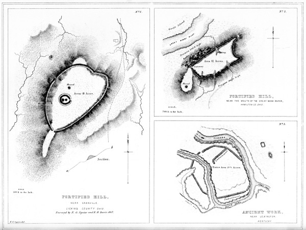
No. 1. Fortified Hill, Near Granville, Licking Co. Ohio.
No. 2. Fortified Hill, Near the mouth of the Great Miami River, Hamilton Co. Ohio.
No. 3. Ancient Work, near Lexington, Kentucky.
Upon the highest part of the ground enclosed in this work, is a small circle, one hundred feet in diameter, within which are two small mounds. There is also another truncated mound, a little distance to the northward of the circle. The mounds within the circle, upon excavation, were found, in common with all similar structures occurring within enclosures, to contain altars. No enduring remains seem to have been deposited upon these altars, which were covered with ashes, intermixed with small fragments of pottery. This is the only hill-work which has p025 been observed to embrace a minor work of the description here represented. The character of the principal enclosure can hardly be mistaken; it is palpably a defensive work, although deficient in that grand essential, a supply of water. If we concede, what can hardly admit of doubt, that the minor structure had a sacred or superstitious origin, we must of necessity arrive at the conclusion that the altars of the ancient people sometimes accompanied their defences.
This work constitutes one of the Newark Group, and is indicated by the letter B in the “Map of six miles of the Newark Valley,” presented upon a succeeding plate. This section of country was once densely populated, as is evidenced by the number and extent of the ancient remains which it includes; and it is probable that the work here noticed, together with one of like character upon the opposite side of the valley, three miles distant, constituted the places of last resort of the ancient inhabitants. The extensive works in the immediate vicinity of Newark, of which a full account is elsewhere given, can hardly be supposed to partake of a military character.
PLATE IX. No. 2.19 FORTIFIED HILL AT THE MOUTH OF THE GREAT MIAMI RIVER, HAMILTON COUNTY, OHIO.
This work is strictly analogous to the other hill-works already described, and is so well exhibited in the engraving as to need little explanation. It occupies the summit of a steep, insulated hill, and consists of a wall carried along its brow, composed of earth, thrown as usual in such cases from the interior. The wall conforms strictly to the outline of the hill, except at the west, where there is a considerable promontory, which is left unenclosed. Upon this promontory is a mound, corresponding doubtless in its purposes with the one on the principal avenue of approach to the remarkable fortified hill, higher up on the Miami, in Butler county (Plate VI.) The late President Harrison regarded this work as admirably designed for defence, and as evincing extraordinary military skill. He says:
“The work at the mouth of the Great Miami was a citadel, more elevated than the Acropolis of Athens, although easier of access, as it is not like the latter a solid rock, but upon three sides is as nearly perpendicular as could be, to be composed of earth. A large space of the low ground was, however, enclosed by walls uniting it with the Ohio. The foundation of that (being of stone as well as those of the citadel) which formed the western defence, is still visible where it crosses p026 the Miami river, which, at the period of the erection of the work, must have discharged itself into the Ohio at a point much lower down than it now does. I have never been able to discover the eastern wall of the enclosure; but if its direction from the citadel to the Ohio was such as it should have been, to embrace the largest space with the least labor, there could not have been less than three hundred acres enclosed.”20
PLATE IX. No. 3. ANCIENT WORK NEAR LEXINGTON, KENTUCKY. [From the RAFINESQUE MSS.]
This work is situated at the junction of the Town and South forks of the Elkhorn river, seven miles from the town of Lexington, Kentucky. Its character is sufficiently explained by the engraving. It is entirely singular in having a stream, of considerable size, running through it. The river has probably encroached upon its original proportions. About one hundred yards to the eastward of this work is a small, oblong enclosure, and a large, elliptical, truncated mound. Other mounds and enclosures occur in the vicinity.21
PLATE X. CLARK’S WORK; NORTH FORK OF PAINT CREEK.22
The work here presented is one of the largest and most interesting in the Scioto valley. It has many of the characteristics of a work of defence, and is accordingly classified as such, although differing in position and some other respects from the entrenched hills just described. The minor works which it encloses, or which are in combination with it, are manifestly of a different character, probably religious p027 in their design, and would seem to point to the conclusion, that this was a fortified town, rather than a defensive work of last resort.
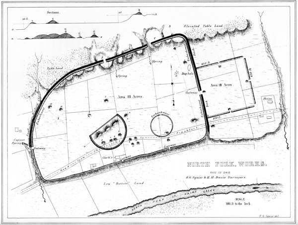
♠ X. North Fork, Works, Ross Co. Ohio.
It is situated on the North fork of Paint creek, on the estate of W. C. CLARK, Esq. and occupies the entire width of the second terrace, which here presents a broad and level plain, of exceeding beauty and fertility. Its general form is that of a parallelogram, twenty-eight hundred feet by eighteen hundred, with one of its corners somewhat rounded. On the side next the creek, it is bounded by a wall four feet high, running along the very edge of the terrace-bank, and conforming to its irregularities; these however are slight. Its remaining sides are bounded by a wall and exterior ditch; the wall is six feet high by thirty-five feet base, and the ditch of corresponding dimensions. The lines ascend the declivity of the table land back of the terrace, and extend along its brow, dipping into the ravines and rising over the ridges into which it has been cut by the action of water. Wherever the ravines are of any considerable depth, the wall has been washed away; but in all cases leaving evidences that it once extended uninterruptedly through. The bank of the terrace is thirty, that of the table-land fifty feet in height.
The area thus enclosed is one hundred and eleven acres. To the right of the principal work, and connecting with it by a gateway at its centre, is a smaller work of sixteen acres area. It is a perfect square; its sides measuring respectively eight hundred and fifty feet. It has gateways at the middle of each side, thirty feet wide, and covered by small mounds, which are placed fifty feet interior to the walls. There are gateways also at the two outer corners, which are unaccompanied by mounds. The opening which leads to the principal enclosure is twice as wide as the others. The walls of the smaller work are much lighter than those of the large one, and have no attendant ditch.
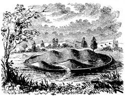
Within the area of the great work, are two small ones: one of them is a perfect circle, three hundred and fifty feet in diameter, bounded by a single slight wall, with a gateway opening to the west; the other is a semi-circular enclosure, two thousand feet in circumference, bounded by a slight circumvallation and ditch as represented in the plan. Within this last enclosure (of which Fig. 3 is a view) are seven mounds; three of which are joined together, forming a continuous elevation thirty feet high by five hundred feet long, and one hundred and eighty broad at the base. (See longitudinal section n o.) The ground within this work appears to be elevated above the general level of the plain, whether designedly or by the wasting of the mounds it is impossible to say. There are other mounds at the points indicated in the plan, most of which have been explored; with what results will appear in the chapter on mounds. It may nevertheless be proper to remark, that nearly all the mounds examined were places of sacrifice, containing altars; thus confirming the opinion already confidently expressed, respecting the character of the work.
Where the defences descend from the table lands to the left, is a gully or p028 torrent-bed, which, before the construction of this work, kept the course indicated by the dotted line x. It was turned by the builders from its natural channel into the ditch, along which it still runs for a considerable distance; but at one place it has broken over the wall, obliterating it for nearly two hundred feet. It is dry at most seasons of the year; and, unless much swollen by the rains, keeps the course of the ditch, terminating in a deep gully, formed by the flow of water from a copious and unfailing spring. This gully is made to answer as a ditch, for the space yet intervening, to the edge of the terrace. It is fifteen feet deep, by sixty or seventy wide. In several other instances, this artificial change in water-courses has been observed.
The gateways of this work are six in number; one opening into the smaller enclosure to the east, two upon the table lands, one to the spring first mentioned, and two others towards the creek. Two considerable springs occur within the walls. It is not necessary, however, upon the hypothesis already advanced in respect to this work, to suppose its ancient population wholly dependent upon these sources for their supply of water; inasmuch as it is very evident that many centuries have not elapsed since the creek, now one hundred rods distant, washed the base of the terrace upon which it stands. Indeed, until recently, and until prevented by dykes above, the creek at its highest stages continued to send a portion of its waters along its ancient channel.
The slight wall along the terrace bank is composed chiefly of smooth, water-worn stones, taken from the creek, and cemented together by tough, clayey earth. The wall of the square is wholly of clay, and its outlines may be easily traced by the eye, from a distance, by its color. It appears, as do the embankments of many other works, to have been slightly burned. This appearance is so marked, as to induce some persons to suppose that the walls were, in certain instances, originally composed of bricks partially baked, but which have in process of time lost their form, and subsided into a homogeneous mass. That they have in some cases been subjected to the action of fire, is too obvious to admit of doubt. At the point z in the lower wall of the square, stones and large masses of pebbles and earth, much burned, and resembling a ferruginous conglomerate, are turned up by the plough. May not this feature be accounted for by supposing the walls to have been originally surmounted by palisades, which were destroyed by the action of fire? Such a cause, however, seems hardly adequate to produce so striking results.
The broken table land upon which the main work extends, forms natural bastions at T and S, which have gateways opening to them. At the point marked C in the embankment, a quantity of calcined human bones are observable.
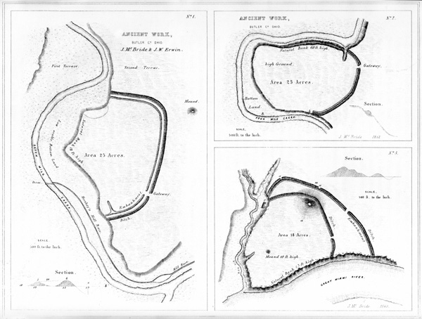
♠ XI. Ancient Work, Butler Co. Ohio.
Such are some of the features of this interesting work; and if their detail has been tedious, it may be urged in extenuation of such minuteness, that descriptions have hitherto been quite too vague and general. Minute circumstances are often of the first importance in arriving at correct conclusions. The comparative slightness of the wall and the absence of a ditch, at the points possessing natural defences,—the extension of the artificial defences upon the table lands overlooking and commanding the terrace,—the facilities afforded for an abundant supply of water, as well as the large area enclosed, with its mysterious circles and sacred p029 mounds,—all go to sustain the conclusion, that this was a fortified town or city of the ancient people. The history of its fall, if its strange monuments could speak, would perhaps tell of heroic defence of homes and altars, and of daring achievements in siege and assault.
The amount of labor expended in the construction of this work, in view of the imperfect means at the command of the builders, is immense. The embankments measure together nearly three miles in length; and a careful computation shows that, including mounds, not less than three millions cubic feet of earth were used in their composition.
Within this work, some of the most interesting discoveries recorded in this volume were made.
PLATE XI. No. 1. [From the Surveys and Notes of JAMES MCBRIDE.]
This highly interesting work is situated in Butler county, Ohio, on the banks of Seven Mile creek, five miles north of the town of Hamilton. It is formed by two irregular lines of embankment, and an exterior ditch, cutting off a jutting point of the second terrace; and has an area of twenty-five acres. These embankments are parallel throughout, and were evidently both made from the same ditch. The outer one has an average height of four, the inner one of three feet. The ditch is between five and six feet deep, by thirty-five feet wide. At the southern portion of the work, both walls and the ditch have their greatest dimensions. The side of the work next the stream is bounded by an abrupt natural bank, eighteen feet high. Distant a few rods from the north-eastern angle of the work, is an elliptical mound eleven feet high; its conjugate and transverse diameters are ninety-two and one hundred and eighteen feet respectively.
This work has a single gateway thirty feet wide. The inner wall, near its southern extremity, curves inward along the terrace-bank for a considerable distance. The first, or creek terrace, is a low alluvion, not subject to overflow. It is evident, however, that the creek once ran at the base of the natural bank (now bounding one side of this work), probably at the period of its construction and occupancy.
PLATE XI. No. 2.
This work affords a very fair illustration of one portion of the defensive structures of the West, already alluded to in the general remarks on the subject, at the p030 beginning of this chapter. It occurs in Oxford township, Butler county, Ohio (Lot 6, Sec. 31, Tp. 5, Range 2, E. M.), at a point on Four Mile creek, where that stream forms a remarkable bend, constituting a peninsula one thousand and sixty feet across at its neck, and one thousand three hundred and twenty feet deep. This peninsula is, in fact, a bold head-land, with precipitous banks, rising sixty feet above the water in the creek, and overlooking the low bottoms that surround it. Across the neck of this peninsula is carried a crescent-shaped wall with an outer ditch. The wall is now but little over three feet in height, and the ditch of corresponding depth. Formerly it was much higher, precluding cultivation. It has been reduced by the present occupant, who has ploughed along it longitudinally, throwing the furrows into the ditch,—a common practice, which is fast reducing and obliterating these interesting monuments of antiquity. A single gateway twenty feet wide leads into the enclosure, which has an area of twenty acres. A terrace, apparently artificial, and thirty feet wide, occurs on the northern bank, at about midway from the water to the top. It may be a natural feature, and caused by the subsidence of the bank from the undermining of the stream. The creek, at one time, unquestionably ran close under the banks of the peninsula; whether or not the recession, leaving the intervening low bottom, B, took place subsequently to the erection of the work, it is of course impossible to determine.
In this work will be remarked the lapping round of the parapet, on the natural bank of the stream at b,—a feature heretofore mentioned, as probably designed to protect the flank of the defence.
PLATE XI. No. 3.
Among the works remarkable as possessing double walls, is the one here presented. It is situated on the Great Miami river, four miles south-west of the town of Hamilton, Butler county, Ohio. The plan obviates the necessity of a detailed description. The outer line of defence consists of a simple embankment five feet high, with an exterior ditch four feet deep. It has a single gateway fifteen feet wide. There are apparent gateways at a a, but the ditch only is interrupted.
Interior to this line of embankment, is another of less dimensions, having also but one opening. At b is a large broad mound, over which, and somewhat below the summit on the outer side, the inner line of embankment is carried. The ditch also continues uninterruptedly over the mound, which is thirty feet high. From its summit, a view of the entire work and surrounding country is commanded. Another mound, ten feet high, occurs at the point indicated in the plan. It is composed of stone and gravel, apparently taken from the river, and probably belongs to the class of mounds denominated “sacrificial,”—the characteristics of p031 which are explained in another chapter. At c, the outer wall appears to have formerly extended down to a lower level; but it has been much obliterated by the washing of the bank. The natural banks, on the side towards the river and next to Big Run, are inaccessibly steep, and between sixty and seventy feet high.
- ♠
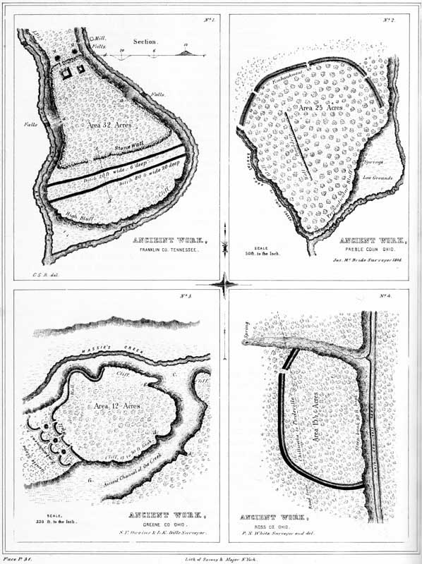
XII. Ancient Works:
No. 1. Duck River, Franklin Co. Tennessee.
No. 2. Preble Co. Ohio.
No. 3. Greene Co. Ohio.
No. 4. Ross Co. Ohio.
The area, embraced within the exterior lines, is a trifle less than eighteen acres. The defensive character of this work can hardly be doubted. It has been suggested that the large mound, over which the inner wall is carried, was designed as a look-out, or alarm post. This may not have been its primary, but it is not impossible that such was its secondary purpose.
PLATE XII. No. 1. STONE WORK, ON DUCK RIVER, TENNESSEE.23
This work is situated in Franklin county, Tennessee, at the junction of the east and west branches of Duck river, and near the main road from Nashville to Winchester.
“It includes an area of about thirty-two acres. The walls are composed of stones of various sizes, collected from the surface of the surrounding country, and rudely thrown together; there is no appearance of their having been united by cement, nor do they exhibit any marks of the hammer. The wall on the south is covered with a layer of earth from one to two feet deep, and is about sixteen feet in thickness at the base, about five feet at the top, and from eight to ten feet high.
“At the northern extremity, near the front wall, are two conical mounds of stone, designated by M, M, in the plan. Each of these mounds is about six feet high, and ten feet in diameter at the base; originally they may have been of somewhat greater altitude, and being on the exterior of the wall, may have been intended as watch towers. In the rear of the mounds is the northern wall, extending to a high bank on either branch of Duck river, and opposite to a waterfall on each, of ten or twelve feet in height. In the northern wall is an entrance or gateway, and in the rear of the gateway are what appear to be the remains of two stone buildings p032 (exaggerated in the plan), one about sixteen feet square, the other about ten feet; the stones are rough and unhewn. Stretching south, the walls are continued on both sides until they reach the points a a, at a bold limestone bluff, which forms a good natural defence. South of the bluff the walls are continued of the same height and thickness, until they reach the angles of the wall fronting the south, which wall also extends from the bank of one river to the other, and has a gateway nearly opposite to that in the northern wall. At the points a a, it is supposed by many who have examined this work, there were formerly excavated passages leading to each branch of Duck river, with steps cut in the rock. There does not, however, appear to be sufficient evidence to sustain this conclusion. The ascent or descent is not very difficult; the steps appear to be formed by the projection of the rock strata; and it was no doubt by these passages that the occupants of the work gained access to the river, and were supplied with water.
“Near the base of the wall on the south side is a ditch, from sixteen to twenty feet wide, and six or eight deep. A short distance farther from the southern wall is another and much more extensive ditch or excavation. In some places it is seventy or eighty feet wide, and from twenty-five to thirty feet deep. The earth from these ditches was probably removed to cover the walls of the fort, or employed in the erection of the neighboring mounds, while the ditches themselves constituted an additional means of defence.
“About three quarters of a mile north of this work is a mound of an oblong form, about twenty-five feet high, one hundred feet long, and twenty broad. On the north-west, about half a mile distant, is another mound of similar form, twenty feet high, eighty long, and sixty wide. These mounds are constructed with the same regularity that distinguishes all the other works of similar character. On both these mounds, trees are growing as large as any in the surrounding forests.
“This work differs in its form, and in the material used in its construction, from all others in the vicinity; but it does not exhibit greater evidence of skill. The difference in form was probably owing to its location; it having evidently been made to conform in all respects to the nature of the ground. Stones were employed because they could be readily procured. Although the hammer had nothing to do with the preparation of the materials, it was nevertheless a work of great labor, and the place of location was selected with a military eye.”
Numerous other defensive works are represented to exist in Tennessee; but very few of them have been surveyed and described. In Bedford county there is a stone work of considerable size, the walls of which are said to be from sixteen to twenty feet wide at the base, and four to five feet wide on the top. Other works adjoin it. It is generally believed to have been erected by De Soto; but in 1819 an oak-tree standing on the wall was cut down, which exhibited three hundred and fifty-seven annual layers, and must consequently have been seventy-eight years old when De Soto landed in Florida.24
A stone work, less in size, but of the same general character, occurs in Larue p033 county, Kentucky. It is situated on one of the bluffs of the Rolling Fork of Salt river, where the creek makes a sharp bend. A plan of it is published in Collins’s History of Kentucky, p. 398. An account of another, of much the same character, in Allen county, is published in the same work, p. 167.
PLATE XII. No. 2.
This work is situated at the junction of the two principal forks of Twin creek, an affluent of the Great Miami river, six miles south-east of the town of Eaton, Preble county, Ohio, on S. E. corner of Sec. No. 10, Township 5, of Range 3, E. M. The plan is from a survey by Mr. MCBRIDE.
In position and mode of construction, this work does not differ materially from a number of others already described. The embankment has an average height of about four feet, and the ditch is not far from five feet deep. The bluff bordering upon the Franklin fork of the creek is for the most part precipitous, and has an average height of between fifty and sixty feet. At its base are several never-failing springs. The height of the bluff fronting upon the other fork varies from thirty feet near the end of the wall, to sixty feet at the junction of the two streams. At its highest part, the bluff consists of a conglomerate, composed of gravel and stones of considerable size. It is very porous, and overhangs about ten feet. There are a number of large cavities in it, which were once supposed to be artificial, and the entrances to subterranean chambers. They are formed by the disintegration of the materials composing the bluff.
Nearly in the centre of the work, in the position indicated in the plan, is a line of large stones. They occupy a space about seven hundred feet long, by twelve broad, and are laid compactly together. Though much sunk in the earth, they are yet distinctly traceable.
PLATE XII. No. 3.25
The fortification here presented affords a fine illustration of the character of the ancient defences of the West. It is situated on Massie’s creek, a tributary of the Little Miami river, seven miles east from the town of Xenia, Greene county, p034 Ohio; and consists of a high promontory, bounded on all sides, excepting an interval at the west, by a precipitous limestone cliff. Across the isthmus, from which the ground gradually subsides towards the plain almost as regularly as an artificial glacis, is carried a wall of earth and stones. This wall is now about ten feet high by thirty feet base, and is continued for some distance along the edge of the cliff where it is least precipitous, on the north. It is interrupted by three narrow gateways, exterior to each of which was formerly a mound of stones, now mostly carried away. Still exterior to these are four short crescent walls, extending across the isthmus. These crescents are rather slight, not much exceeding, at the present time, three feet in height. The cliff has an average height of upwards of twenty-five feet, and is steep and almost inaccessible. At d d are breaks in the limestone, where the declivity is sufficiently gentle to admit of a passage on horseback. At E is a fissure in the cliff, where persons may ascend on foot. The valley, or rather ravine, C C, is three hundred feet broad. Massie’s creek, a considerable stream, washes the base of the promontory on the north. The area bounded by the cliff and embankment is not far from twelve acres. The whole is now covered with the primitive forest.
The natural strength of this position is great, and no inconsiderable degree of skill has been expended in perfecting its defences. A palisade, if carried around the brow of the cliff and along the summit of the wall, would render it impregnable to savage assault. About one hundred rods above this work, on the opposite side of the creek, is a small circle, two hundred feet in diameter, enclosing a mound. About the same distance below, upon the same bank, is a large conical mound, thirty feet in height and one hundred and forty feet in diameter at the base. No other works of magnitude are known to exist, nearer than the great defensive structure on the Little Miami (Plate VII.), twenty-one miles distant.
PLATE XII. No. 4.
This work, unlike those just described, occurs upon the high table-land bordering the Scioto river bottoms, on the west bank of that stream, twelve miles above the city of Chillicothe. It consists of a single wall and ditch, cutting off a high promontory, formed by the declivity of the table land, and the bank of a wide and deep ravine. These banks are not far from one hundred feet in height, and at most points are absolutely inaccessible. It has a single gateway, opening towards a copious spring, at the head of the ravine just mentioned. The wall is four feet high, and the ditch of corresponding depth. There are no mounds within this enclosure, nor in its immediate vicinity; but a number of natural elevations are discernible, which an unpractised eye might mistake for works of art. In this instance, they may have subserved some of the purposes of the mounds. p035 The water flowing through the ditch has formed deep gullies at the points where it terminates. The soil is here clayey and hard. The level at the foot of the promontory upon which this work stands, is the first or latest-formed terrace of the Scioto; indicating that the river, at one period, swept along where the Ohio canal now passes.
- ♠
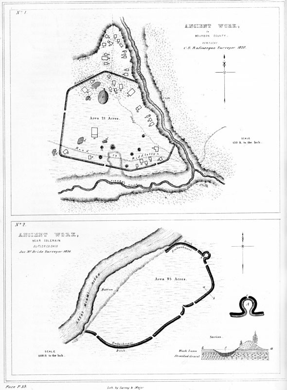
XIII. Ancient Works:
No. 1. In Bourbon Co. Kentucky.
No. 2. Near Colerain, Butler Co. Ohio.
PLATE XIII. No. 1. [From the RAFINESQUE MSS.]
This work, which seems incontestibly of a defensive character, is situated on Stoner’s creek, at the mouth of Flat Run, in Bourbon county, Kentucky. The wall throughout is composed of earth, and is slight, not exceeding three or four feet in height. A number of mounds and excavations occur within the enclosure, together with other remains, consisting of raised outlines, two or three feet broad and one foot high. These are indicated by the letter a, and are denominated “remains of dwellings” by Rafinesque. Twenty of them are found within, and fourteen without the walls; the latter occupying the point of land to the north of the enclosure. The larger one is called “the palace” by our fanciful authority, and is represented to be eighty feet long by seventy-five broad. To the north of “the palace” is an elliptical, hollow area, fifteen feet deep; it is indicated by the letter c. A number of irregular excavations are marked by the letter d. The Lexington road passes through this work.
PLATE XIII. No. 2.26 [From the Surveys and Notes of JAMES MCBRIDE.]
This work is one of the first magnitude; and in many respects bears a close resemblance to the great work on the North fork of Paint creek. (See Plate IX.) It is situated near the village of Coleraine, Hamilton county, Ohio, on the right bank of the Great Miami river, and encloses an area of ninety-five acres. The walls have an average height of nine feet, and have an exterior ditch of proportionate dimensions. The terrace upon which the work is located is thirty feet above the usual stage of water in the river. p036
The outwork, of which A is an enlarged plan, possesses all the features of a bastion, and was perhaps designed as such. It could hardly have been intended as a gateway; for, although the ditch is interrupted for a narrow space at c, the embankment is unbroken.
The transverse section of the wall, a b, demonstrates the artificial origin of the work, which it is not probable any one would be disposed to deny. The upheaved gravel upon the exterior side of the wall, wherever it is under cultivation, supports dwarfed and sickly maize; while on the inner side, the grain is luxuriant. This feature and its cause are indicated in the section.
This work, which was undoubtedly defensive, commands a large peninsula, two miles in circumference, formed by a singular bend in the river. About two hundred paces distant from this enclosure, in a southern direction, is the site of old Fort Dunlap, somewhat celebrated in the early history of the Miami valley. It was invested by the notorious Simon Girty, with a force of six hundred Indians, in 1791, without success. Some distance from the fort, and still further to the south, is a hill three hundred feet in altitude, upon the top of which are two mounds, measuring five and ten feet in height, respectively. They are composed of earth and stones, considerably burned.
-
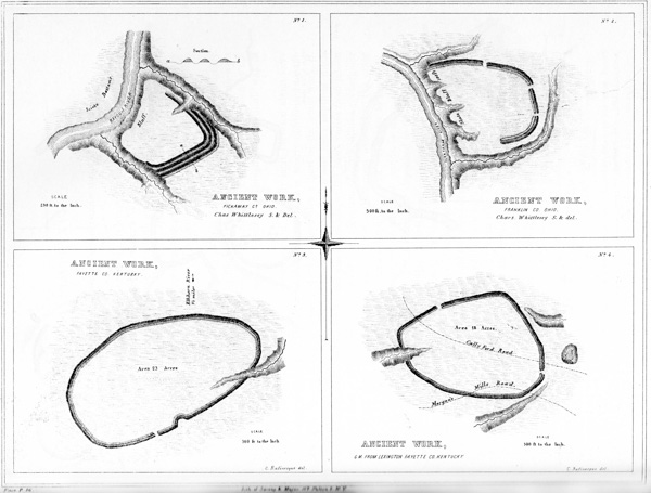
PLATE XIV.
NUMBER 1.—This work is situated near the north line of Pickaway county, Ohio, on the right bank of the Scioto river. It is entirely analogous to many of those already described; and is only remarkable as possessing three lines of embankment, with corresponding ditches, as shown by the section a b. “The ditches are here interior to the walls, which circumstance is adverse to the idea of a defensive origin. The situation, however, with a steep bank and deep water on one side, and deep ravines with precipitous banks on the others, is one of great natural strength and adaptation for defence. The walls are now very slight.”
- ♠
XIV. Ancient Works:
No. 1. Pickaway Co. Ohio.
No. 2. Franklin Co. Ohio.
No. 3. Fayette Co. Kentucky.
No. 4. 6 miles from Lexington, Fayette Co. Kentucky.
- ♠
NUMBER 2.—This work is, in most respects, similar to the one last described. It is situated four and a half miles north of Worthington, Franklin county, Ohio, on the left bank of Olentangy creek. The artificial defences consist simply of an embankment of earth, three feet in height, with an exterior ditch of corresponding depth. The natural defences are sufficiently obvious. Both of these plans are from surveys by CHARLES WHITTLESEY, Esq.
NUMBERS 3 AND 4.—The character of these works is sufficiently explained by the engravings. From the position of the ditch and other obvious circumstances, they have been classed as of defensive origin. They are from the Rafinesque MSS. p037
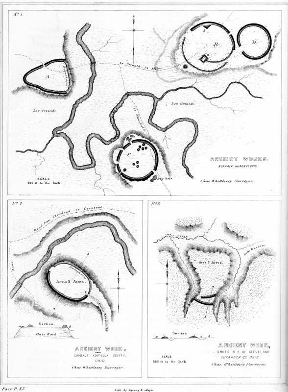
PLATE XV. ANCIENT WORKS IN NORTHERN OHIO.
The succeeding plans and descriptions, relating to aboriginal monuments of northern Ohio, were communicated by CHARLES WHITTLESEY, Esq., of Cleveland, whose archæological researches have been both extensive and accurate.
- ♠
XV. Ancient Works:
No. 1. Norwalk, Huron Co. Ohio.
No. 2. Near Conneaut, Ashtibula Co. Ohio.
No. 3. 3 Miles S. E. of Cleveland, Cuyahoga Co. Ohio.
-
NUMBER 1. Ancient Works near Norwalk, Huron county, Ohio.—“The relative positions of the various works composing this group are given by the eye; they are nevertheless sufficiently accurate. The individual works are laid down from actual survey.
“The enclosure A is principally in a field long cultivated, and is scarcely traceable. The ditch is exterior to the wall, and exists only upon the north-west and south-west sides. The walls were very much reduced: when first seen by the whites, they scarcely exceeded eighteen inches in height. The ditch was of corresponding depth.
“The enclosure B occupies a promontory of gravelly land, elevated about forty feet above the creek. The detached circular work D is nearly obliterated by the plough. It had a slight exterior ditch, as had also a part of the main work B. The present height of the wall is from one to two and a half feet; depth of ditch somewhat less. The breadth of the embankments, at the base, varies from fifteen to thirty feet. Within the enclosure B is an elevation of earth, a, of a rectangular form, about three feet high, from which a low embankment extends to the outer wall. At b is a similar elevation connected with the wall. Exterior to the work, and occupying the point of the headland on which it stands, is a small mound, from which a skull was taken some years since, and deposited in the museum of the Willoughby University of Lake Erie. In it were also found the two valves of what is described as a clam shell, each having three holes near the beak, suggesting the probability of a handle having been attached at that point, so as to constitute a spoon or ladle. Besides these were found two pipes of clay, and one of white marble, partly disintegrated, about two and a half inches high; also, a flat piece of a hard grayish slate, half an inch thick, wrought to an edge at the broad end, with a hole pierced obliquely through it, called by the finders ‘a hoe.’ A small earthen vessel, of coarse material and rude finish, holding about a pint, accompanied these relics. All these articles were taken from the vicinity of coals and ashes, and burned human bones. In the hands of one of the skeletons were pieces of clay, which had evidently been placed in them while in a plastic state, inasmuch as they still retained the impressions of the fingers, joints, and palms.27 p038
“The work C occupies a corresponding position with those already described, as belonging to this group. The peninsula upon which it is situated is approachable only from the south. Upon this side the ditch is irregular. The mounds of the central group have been opened; but it is not known with what results. They are quite low, not exceeding three feet in height. The wall of this work is very slight. At the south-west is a graded passage to the lower level of the river bottom.
“Huron river or creek, several branches of which join it at this point, is always fordable; and the bluffs which surround the enclosures are not very difficult of ascent. These works may have been designed for defence,—perhaps they were ‘walled towns;’ but they do not occupy positions of great natural strength. The grounds adjacent to the river are low, and in places swampy: the river evidently once ran at the base of the bluff occupied by the enclosure B.”
NUMBER 2. Ancient Work near Conneaut, Ashtabula county, Ohio.—“This work is at present very slight, but distinctly traceable. The sketch is a mere coup d’œil, without measurements. The elevation of the bluff upon which it stands is about seventy feet; and the banks of aluminous slate are, upon the north, very precipitous. It would be entirely impracticable for a body of men to ascend upon this side, without ladders and scaling apparatus. Upon the south side it would be practicable for an assailant to ascend, unless prevented by some artificial obstacle. Upon this side, the wall which skirts the brow of the hill is accompanied by an outer ditch, while upon the north there is a simple embankment. The ascent, C C, is gradual and easy. Within the enclosure the earth is very black and rich; outside of the walls it is a stiff clay. The adjacent bottoms are very fertile, and the creek is everywhere fordable. There can be no doubt that this was a fortified position.”
Near the village of Conneaut are a number of mounds, and other traces of an ancient population, among which is an aboriginal cemetery regularly laid out, and of great extent.
NUMBER 3. Ancient Work three miles south-east of Cleveland, Cuyahoga county, Ohio.—“This stronghold is on the great plain which extends some miles back from the shores of Lake Erie, gently declining towards it, and by many supposed to have been its ancient bed. Many portions of this plain are two hundred feet above the present surface of the lake. The marl, sand, and gravel deposits, of which this formation is made up, are from one hundred to three hundred feet thick.
“These materials are readily washed away by rains, springs, and rivulets; so that the flat region is intersected by numberless deep and narrow ravines, leaving bluff headlands, and furnishing the ancient people with numerous positions protected on nearly every side by deep gullies and high precipitous banks, and capable, with little artificial aid, of easy defence. These features of the country, and the manner in which they were made available for defensive purposes, are well illustrated in the example here presented. The isthmus connecting this promontory with the general table is but about two hundred feet wide, and is defended by parallel lines p039 of embankments accompanied by exterior ditches. There seems to be no gateway or opening through the outer line; the inner one, however, terminates before reaching the bank of the ravine on the left, leaving a narrow passage-way upon that side. The natural banks have an angle of forty-five to sixty degrees with the horizon, and are in many places wet and slippery, and utterly inaccessible. About one-fourth of a mile to the eastward of this work, is a mound ten feet high, by sixty feet in diameter at the base.”
-
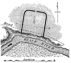 Fig. 4.
FIG. 4.—“This work is situated on the right bank of Black river, in Sheffield township, Lorain county, Ohio. The bank of the river is here nearly perpendicular and quite impossible of ascent, except by ropes or something equivalent, and is about sixty feet high. The water level of the lake reaches to this spot, and the river is in consequence too deep to be forded. The position seems to have been selected for the purpose of defence, although the land back of it is on the same level.
“The artificial defences consist of double embankments, with an intermediate ditch. The embankments are very slight, not much exceeding a foot in height. It is not improbable that the ditch was occupied by wooden pickets, supported by embankments on either side. The work could not have afforded any protection, except with additional defences,—palisades, or something of the sort. Within the enclosure the soil is very rich; but without, it is clayey and poor. The gateway, opening to the north, is forty feet wide.”
-
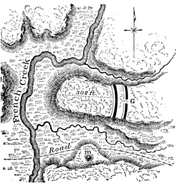 Fig. 5.
FIG. 5.—“This work is situated in the same township with that last described. It is bounded upon three sides by a vertical slate bluff, and defended upon the fourth by a double line of embankments, with accompanying exterior ditches. The height of the walls is about eight feet, measuring from the bottom of the ditches. There is an opening or passage-way through the outer line, but none through the inner. We may account for this circumstance by supposing the latter to have been thrown up after the commencement of a siege. As usual, the soil within this work is very rich compared with that without the walls. Under any mode of attack known to barbarians, this must have been an impregnable work. Upon the other side of the creek, are bluffs of equal height with that upon which this defence is located; but they are too far distant to afford positions of annoyance to besiegers.” p040
-
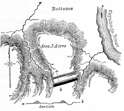 Fig. 6.
FIG. 6.—“This work is situated upon the Cuyahoga river, eight miles above Cleveland, Ohio. It corresponds, in all essential particulars, with the one on the same stream, five miles below, which has already been described. The ground has been so long under cultivation that the parallels are with difficulty traced; they are not more than a foot or eighteen inches high. The ditch is of corresponding depth. Between the lines there is a depression,—undoubtedly artificial in its origin, but now much deepened by rains. The soil is a clay-loam, and the area very difficult of access from all sides. The bluff is here from one hundred and fifty to two hundred feet high.”
-
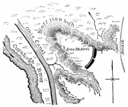 Fig. 7.
FIG. 7.—“This work is situated on the Cuyahoga river, two miles below that last described, with which it coincides in respect to position. It has, however, but a single wall and ditch; the latter is from two to four feet deep, the former of proportionate height. There is a gateway or unexcavated passage across the ditch, but no corresponding opening in the embankment. There is, however, a narrow, unprotected space between the left end of the defences and the bluff. The elevation of the ground is here about two hundred feet above the river, the soil sandy, and lately put under cultivation. The bluff is steep and difficult of ascent. Water is found in the adjacent ravines, which are narrow and deep.”
-
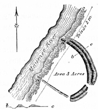 Fig. 8.
FIG. 8.—“This work is situated on the right bank of the Maumee river, two miles above Toledo, in Wood county, Ohio. The water of the river is here deep and still, and of the lake level; the bluff is about thirty-five feet high. Since the work was built, the current has undermined a portion, and parts of the embankment are to be seen on the slips at a a. The country for miles in all directions is flat and wet, though heavily timbered, as is the space in and around this enclosure. The walls, measuring from the bottoms of the ditches, are from three to four feet high. They are not of uniform dimensions throughout their extent; and as there is no ditch on the south-west side, while there is a double wall and ditch elsewhere, it is presumable that the work was abandoned before it was finished.” p041
“Nothing can be more plain, than that most of the remains in northern Ohio, particularly those on the Cuyahoga river, are military works. There have not yet been found any remnants of timber in the walls; yet it is very safe to presume that palisades were planted on them, and that wooden posts and gates were erected at the passages left in the embankments and ditches.
“All the positions are contiguous to water; and none of them have higher land in their vicinity, from which they might in any degree be commanded. Of the works bordering on the shore of Lake Erie, through the State of Ohio, there are none but may have been intended for defence; although in some of them the design is not perfectly manifest. They form a line from Conneaut to Toledo, at a distance of from three to five miles from the lake; and all stand upon or near the principal rivers. There are probably five of them as yet unknown, to one that has been publicly noticed. In the interior of the State, so far as my observation has extended, this class of works is wanting. Their place is supplied by larger works, situated on low lands, their strength depending more on artifice than on position.28 They are so different, that I am disposed to regard them, not only as designed for other purposes, but as the work of another and probably later people.
“The most natural inference in respect to the northern cordon of works is, that they formed a well-occupied line, constructed either to protect the advance of a nation landing from the lake and moving southward for conquest; or, a line of resistance for a people inhabiting these shores and pressed upon by their southern neighbors. The scarcity of mounds, the absence of pyramids of earth, which are so common on the Ohio, the want of rectangular and other regular works, at the north,—all these differences tend to the conclusion that the northern part of Ohio was occupied by a distinct people.
“At the north there is generally more than one wall of earth, and the ditches are invariably exterior. There are sometimes passages, or ‘sally-ports,’ through the outer parallel, and none through the inner one. There is also, in general, a space between the parallels sufficiently large to contain a considerable body of fighting men. By whatever people these works were built, they were much engaged in offensive or defensive wars. At the south, on the other hand, agriculture and religion seem to have chiefly occupied the attention of the ancient people.
“In view of the above facts, we may venture to suggest a hypothesis, without undertaking to assign to it any more than a basis of probability. Upon the assumption that two distinct nations occupied the State,—that the northern were warlike, and the southern peaceful and agricultural in their habits,—may we not suppose that the latter were overcome by their northern neighbors, who built the military works to be observed upon the Ohio and its tributaries, while the more regular structures are the remains of the conquered people?” p042
The differences between the northern and southern earthworks, pointed out by Mr. Whittlesey, are not greater than would naturally be exhibited between the structures of a sparse frontier population, and those erected by more central and dense communities. Works, generally corresponding with those here described, are found still further to the northward and eastward; extending to the Genesee river and its tributaries in New-York, and even to the head waters of the Susquehanna in Pennsylvania,—which seems to have been the extreme limit to which the mound-builders penetrated in that direction. From plans previously presented, it will be seen that precisely analogous works occur in Kentucky and Tennessee. It will be seen also, in a succeeding chapter, on the “Antiquities of the Southern States,” that similar structures are found in Mississippi, and elsewhere along the Gulf.
The examples of defensive works here presented will serve to give a very accurate conception of this class of structures. By a minute attention to their various details, we are prepared to estimate the judgment, skill, and industry of their builders. No one can rise from such an examination, except with the conviction that the race, by whom these works were erected, possessed no inconsiderable knowledge of the science of defence,—a degree of knowledge much superior to that known to have been possessed by the hunter tribes of North America previous to the discovery by Columbus, or indeed subsequent to that event. Their number and magnitude must also impress the inquirer with enlarged notions of the power of the people commanding the means for their construction, and whose numbers required such extensive works for their protection. It is not impossible that, like the defensive enclosures of the Polynesian Islanders, they were to a certain extent designed to embrace cultivated fields, so as to furnish the means of subsistence to their defenders, in the event of a protracted siege. There is no other foundation, however, for this suggestion, than that furnished by the great size of some of them. The population that found shelter within their walls must have been exceedingly large, if their dimensions may be taken as the basis of a calculation.
There is no positive evidence that the mound-builders fully understood the value of the bastion in their works of defence; although they seem, in some instances, to have secured the projecting points of the hills on which their defences are situated, with a view of enfilading the walls. The fortified hill near the mouth of the Great Miami, (Plate IX,) and Fort Hill, in Highland county, afford examples. These projecting points could however, from their wide distance apart, but very imperfectly answer the purpose of bastions; and the supposition that they were thus used is rendered less probable, from the fact that the walls oftener cut off these points than accommodate themselves to them. It is not improbable, notwithstanding the absence of direct evidence to that effect, that bastions of wood were erected at intervals along the walls. Such constructions would undeniably be the most simple and efficient for the purposes desired. The numerous openings in the walls of many of these works, although indiscriminately denominated gateways, were clearly not always designed as such. It is not unwarrantable to suppose that they mark the positions of wooden constructions, like the block-houses of later times, p043 which projected beyond the walls, and answered the double purpose of bastions and watch-towers. The very regular intervals between these openings, particularly in the great work on the Little Miami, (Plate VII,) and the Fortified Hill in Highland county, just mentioned, (Plate V,) would seem to favor this hypothesis. Of course we cannot now expect to find any traces of wooden structures, even if such entered into the original defences.
The walls of earth and stone which constitute all that remains to us of these aboriginal fortifications, although often high and heavy, would nevertheless, in themselves, furnish very imperfect means of protection and resistance. Earth cannot be heaped up so as very much to impede an assailant; and the stone works, as far as noticed, do not appear to have been constructed of stone regularly laid, so as to present a vertical or inaccessible front to an enemy. These circumstances render it sufficiently obvious that the walls were surmounted by palisades, or by something equivalent. We are sustained in this conclusion by the concurrent practices of all nations, known to construct permanent works of this description. The ramparts of the Roman camps were strengthened by stakes fixed on the top; and to this day, the walls of E’Pas, or entrenched hills of the New Zealanders, are surmounted by palisades. Such also is the present practice of some of the tribes on the Missouri,—the Minatarees, Rickarees, and others. The walls of some works, which, from their position and other circumstances, are manifestly of defensive origin, are so slight that it would be absurd to suppose them designed for protection, unless crowned with palisades. Most of those of northern Ohio are subject to this remark. It has been asserted by certain writers on American antiquities, that traces of palisades are yet to be seen in some of them. Aside from the palpable improbability of anything of the sort, it is proper to remark that no such evidences have been observed in the course of our own investigations. A very few years of exposure would suffice to obliterate all traces of wood in these constructions.
We have already had occasion to remark the skill with which the gateways or entrances to these enclosures are sometimes protected by over-lapping or concentric walls, horn-works, etc. It is rational to conclude that means were made use of by the builders to close the entrances effectually, when desired. How this object was accomplished is, of course, entirely a matter of conjecture. The Australians, in case of alarm, completely close their entrenchments with stones or other obstructions. Entrance is effected only by a succession of posts of different lengths, like a stile, or by the aid of notched trees.
In connection with many of the defensive structures, mounds are occasionally to be found, so placed as to suggest the purposes of watch-towers, look-outs, or alarm-posts. They are sometimes exterior, and sometimes interior to the walls of the enclosures, and occasionally incorporated with them. Plate XI (Nos. 1 and 3) affords examples. It is possible that this was not the primary, perhaps not even the secondary purpose of these mounds. Proper excavations would settle the question. In the absence of these, we can only appeal to such light as analogy affords us in our inquiry. Such mounds were erected by the ancient Britons for purposes of observation, both in advance of their other defences and within them; p044 and the early Spanish writers speak of similar erections, for similar purposes, by the Floridian Indians. The New Zealanders compass the same ends by raising a tree, the branches of which have been lopped off within a few inches of the trunk, at some elevated point within their works.
The almost invariable presence of water within, or in immediate proximity to these enclosures, has been the occasion of frequent remark in the foregoing descriptions. In the absence of springs and streams, as also where, from position, access to such supplies of water is impracticable, we find their place supplied by reservoirs; an evidence of the forethought of the builders, as also an index to the true character of the works in which these features occur.
The vast amount of labor necessary to the erection of most of these works precludes the notion that they were hastily constructed to check a single or unexpected invasion. On the contrary, there seems to have existed a System of Defences extending from the sources of the Alleghany and Susquehanna in New York, diagonally across the country, through central and northern Ohio, to the Wabash. Within this range, the works which are regarded as defensive are largest and most numerous. If an inference may be drawn from this fact, it is that the pressure of hostilities was from the north-east; or that, if the tide of migration flowed from the south, it received its final check upon this line. On the other hypothesis, that in this region originated a semi-civilization which subsequently spread southward, constantly developing itself in its progress, until it attained its height in Mexico, we may suppose that from this direction came the hostile savage hordes, before whose incessant attacks the less warlike mound-builders gradually receded, or beneath whose exterminating cruelty those who occupied this frontier entirely disappeared, leaving these monuments alone to attest their existence, and the extraordinary skill with which they defended their altars and their homes. Upon either assumption, it is clear that the contest was a protracted one, and that the race of the mounds were for a long period constantly exposed to attack.29 This conclusion finds its support in the fact that, in the vicinity of those localities, where, from the amount of remains, it appears the ancient population was most dense, we almost invariably find one or more works of a defensive character, furnishing ready places of resort in times of danger. We may suppose that a condition of things prevailed somewhat analogous to that which attended the advance of our pioneer population, when every settlement had its little fort, to which the people flocked in case of alarm or attack.
It may be suggested that there existed among the mound-builders a state of society something like that which prevailed among the Indians; that each tribe had its separate seat, maintaining, with its own independence, an almost constant warfare against its neighbors, and, as a consequence, possessing its own “castle,” as a place of final resort when invaded by a powerful foe. Apart from the fact, p045 however, that the Indians were hunters averse to labor, and not known to have constructed any works approaching in skilfulness of design or in magnitude those under notice, there is almost positive evidence that the mound-builders were an agricultural people, considerably advanced in the arts, possessing a great uniformity throughout the whole territory which they occupied, in manners, habits, and religion,—a uniformity sufficiently well marked to identify them as a single people, having a common origin, common modes of life, and, as an almost necessary consequence, common sympathies, if not a common and consolidated government.
The question whether the North American Indians constructed defensive works of this description, is one of much importance, but which cannot be fully discussed in this connection. All the early writers concur in representing that the Indian tribes, from Florida to Canada, possessed common modes of defending their villages and protecting themselves from the attacks of their enemies. Their fortifications consisted of rows of pickets firmly fixed in the ground, sometimes wattled together, but occasionally placed so far apart, as to permit missiles of various kinds to be discharged between them upon an assailant.30 They seldom had more than a single entrance, which, among the Floridians, was not direct, but circuitous. Entrenchments of earth, consisting of an embankment and ditch, do not appear to have been constructed by them. It seems, however, that of late years, the Indians to the westward of the Mississippi, particularly the Mandans and Rickarees, have constructed entrenchments of earth, surmounted by palisades.31 But whether the practice is of recent introduction or otherwise, it is difficult to say. It is stated by Prince Maximilian, in his Travels in America, that the defences of the Mandan village of Mih-tutta-hang-kush, which consisted of a wall and ditch, were built by whites, who were employed by the Indians for that purpose.32
The defences of the nations of the central portion of the Continent, and especially those of the Mexicans and Peruvians, so far as we are informed concerning them, bore a close resemblance to those of the mound-builders, although exhibiting a superiority entirely consonant with the further advance which we are justified in supposing they had made in all the arts, including the art of defence.33 Some reference has already been had to the actual identity which a few of the defences of the West exhibit with those of Mexico, in some of their most interesting features. These resemblances might be pointed out in detail, but they will readily suggest themselves to the Archæologist. The usual mode of fortification in Peru consisted in throwing up a series of embankments around the summits of isolated hills,—a practice which was common among the ancient Celts, and which is still preserved among the Australian and Polynesian islanders.34 Ulloa observes, p046 in respect to their numbers, that “one scarcely meets with a mountain without them.” Precisely similar modes of defence prevailed among the savage South American tribes, who invariably crowned their entrenchments of earth with palisades of wood.35
The traces of ancient fortifications in the northern part of the State of New York, and upon the head waters of the Susquehanna in Pennsylvania, may, it is believed, be referred with entire safety to the same hands with those of the Mississippi valley. It will be seen that they have a close resemblance to those of northern Ohio, both in position and structure.
- ♠
-
FOOTNOTES TO CHAPTER II.
-
8 This observation is confirmed by all who have given attention to the subject, in the Ohio and Upper Mississippi valleys. Along the Gulf, and at points on the Lower Mississippi, where the entire country is low, and subject to inundation, and where the operation of natural causes is rather to elevate than depress the beds of the streams, some of the ancient works are invaded by water.
-
9 This work is marked C in the “Map of a Section of Six Miles of the Paint Creek Valley,” Plate III.
-
10 It has been suggested that perhaps the walls of stone were sustained or surmounted by wooden structures of some sort, the destruction of which, in whole or in part, by fire, caused the appearances noticed in the text. The suggestion that these are the traces of “ancient furnaces,” is not to be entertained for an instant.
-
11 This work was first described, though not first surveyed, by Professor LOCKE, of Cincinnati, in 1838. His description and plan—to the accuracy and fidelity of which every visitor can bear witness—were published in the “Second Annual Report of the Geological Survey of Ohio.”
-
12 This sandstone, it should be remarked, to prevent misapprehension, is the “Waverley sandstone,” underlying the coal series, and which is found capping most of the hills in this region. It occurs in successive layers, of from a few inches to several feet in thickness. It is quite friable, and quarries readily.
-
13 “One of the mounds at Marietta must be more than eight hundred years old; for Dr. Hildreth counted eight hundred rings of annual growth in a tree which grew upon it.”—Lyell’s Travels in North America, vol. ii. p. 29. See also Second Geological Report of the State of Ohio, p. 268.
-
14 De Solis describes this Tlascalan work as “a great wall which ran from one mountain to the other, entirely stopping up the way: a sumptuous and strong piece of building which showed the power and greatness of the owner. The outside was of hewn stone cemented with mortar of extraordinary strength. It was twenty feet thick and a fathom and a half high; and on the top was a parapet after the manner of our fortifications. The entrance was narrow and winding; the wall in that part dividing and making two walls, which circularly crossed each other for the space of ten paces.”—History of the Conquest of Mexico, p. 139.
-
15 An account of this work, accompanied by a very good plan, appeared in the “Portfolio,” (a periodical published in Philadelphia,) for the year 1809. Both plan and description were copied by Mr. Atwater, in his memoir, in the first volume of the “Archæologia Americana.” It was also briefly described by Dr. Drake, in the chapter on Antiquities contained in his “View of Cincinnati.” Since that period, it has been the object of frequent visit and remark.
-
16 Dr. Drake, in the chapter on antiquities, in his “View of Cincinnati,” has the following notice of this work:
“The adjacent hill, at the distance of half a mile, and at the greater elevation of about one hundred feet, is the site of a stone wall, mainly circular, and enclosing perhaps twenty acres. The valley of the river on one side, and a deep ravine on the other, render access to three-fourths of this fortification extremely difficult. The wall is carried generally along the brow of the hill, in one place descending a short distance, so as to include a spring. The silicious limestone of which it was built, must have been transported from the bed of the river, which, for two miles opposite these works, does not at present afford one of ten pounds weight. They exhibit no marks of the hammer or any other tool. The wall was laid up without mortar, and is now in ruins.”
-
17 Long’s Second Expedition, vol. i, pp. 54–66.
-
18 Surveyed by JAMES MCBRIDE, Esq and SAMUEL FORRER, Esq of the Ohio Board of Public Works.
-
19 The above plan is copied from the map accompanying Harrison’s published Address before the Historical Society of Ohio.—Transactions, vol. i. p. 217.
-
20 Transactions Historical Society of Ohio, vol. i. p. 225.
-
21 This work is not placed in the connection which it was designed to occupy. Its position in the text was determined by circumstances; and its character will be better understood in the progress of this chapter.
-
22 This plan is from an original, minute survey by the authors. A plan and description of the same work were published by Mr. Atwater in the “Archæologia Americana.” It will be found to differ in some important respects.
-
23 Two plans of this work exist among the MSS. of Rafinesque, which differ slightly from each other. One of them coincides, however, in all important particulars with a plan published some years ago in the “Western Messenger,” and has therefore been adopted as probably essentially correct. The description in the “Messenger,” which seems to have been written by an intelligent observer, is also adopted. It is amply sustained by the account of Judge Haywood, and by other evidence, and it is thought may be relied on in all respects.
-
24 Haywood’s Tenn. vol. ii.
-
25 This work is laid down from surveys made by S. T. OWEINS, surveyor of Greene county, and by L. K. DILLE, M.D. The survey by Mr. Oweins was kindly communicated by W. B. Fairchild, Esq. of Xenia. The work has also been personally examined by the authors.
-
26 This work is marked C, in the map of a “Section of six miles of the Miami valley,” Plate III.
-
27 These relics, as also the skeletons found with them, were probably those of the more recent Indians, and constituted a second and comparatively late deposit. The burned remains, doubtless, resulted from the original burial by fire. Incremation was extensively practiced by the mound builders.
-
28 “There is a small enclosure on the south line of Franklin county, and another in Pickaway county, which closely resemble those along the lake shore.” See Plate XIV, Nos. 1 and 2.
-
29 “The Ohio fortresses were not erected for defence against a casual invasion. The size of the walls, and the solidity of their construction, show that the danger which they were designed to arrest was of constant recurrence.”—Harrison’s Discourse, Transactions Ohio Historical Society, vol. i. p. 263.
-
30 Charlevoix, Canada, vol. ii. p. 128; Loskiel, p. 53; Du Pratz, Louisiana, p. 375; Herrara, History of America, vol. v. p. 324.
-
31 Catlin’s North American Indians, vol. i. p. 81; Lewis and Clark, ubi supra.
-
32 Travels in North America, pp. 173, 243.
-
33 De Solis, History of Mexico, p. 54; Juarros, History Guatemala, p. 462; Stephens’s Yucatan, vol. i. pp. 165, 230; Molina, vol. ii. pp. 10, 68; Ulloa, vol. ii. p. 27.
-
34 Ellis’s Polynesian Res. vol. i. pp. 313, 314; Cook’s Second Voyage, ubi supra; Pollack’s New Zealand, vol. ii. p. 26.
-
35 Charlevoix, History of Paraguay, vol. i. p. 156.
-